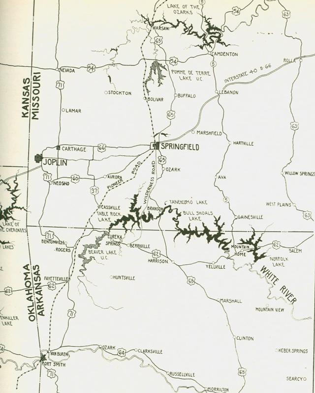
Two Important Pioneer Roads
From The Ozarks Mountaineer, March 1960, page 5.
Two important pioneer roads of the Ozarks -- A sketch by Winslow A. Kingman
"Historical facts are lacking to determine the actual beginning of the principal pioneer road that traversed and served the Ozarks. It began at Boonville (Mo.), important port on the Missouri River and proceeded south through Warsaw, Bolivar, Springfield, Cassville, Fayetteville and Fort Smith to the southwest beyond. The Butterfield Mail traveled part of it in 1858 and it then was well established with many communities along it. Springfield for instance already had become, by Civil War time, an important town, a center of a wide trading territory and a transportation hub. The last factor has contributed much to the community's subsequent growth.
"The Pioneer Road was the artery for our early settlers, who with their goods disembarked at Boonville or at Warsaw, headquarters of navigation on the Osage River and proceeded on their way south into the interior of the Ozarks. White men took over this road from the Indians. Traces of four different Indian cultures have been found throughout the region, the first, Archaic, going back some thousands of years. The last were the Osage, here when the pioneers came. The Indians traveled for many miles in hunting and fishing expeditions and in their migrations and established well-used trails in so doing. Just when, over the centuries of their occupancy, the trails were established is not known today. The Pioneer Road was one. History does show, for instance, that before 1800 journeys of long distances were made over it for salt at the licks near Boonville later developed by the sons of Daniel Boone and shipped by keel boat to St. Louis. The course that the road followed manifests the Indian heritage. It follows ridges and springs, characteristic of Indian trails. Early surveys made between 1830 and 1840 to establish section lines carry this road on their maps.
"The first telegraph line to serve the Ozarks was built along it. At the time of the Butterfield Mail, a line reached from St. Louis to Jefferson City and was extended on to Springfield and Fort Smith following its right of way. The line had been finished as far as Brighton, 14 miles north of Springfield, when the first Butterfield coach, westward bound, began its journey from Tipton (Mo.).News that the coach had departed was flashed by wire to Brighton and then relayed by horseback to Springfield to prepare for the big reception to be accorded this first transcontinental movement of the mail. The line shortly thereafter reached Springfield and in two months was extended to Fort Smith. The road then became known also as the Wire Road. Another road, also bearing that name carried wires from Springfield to St. Louis via Rolla but that line was established later by union forces during the Civil War.
"The Wilderness Road
[not to be confused with the Wilderness Road into Kentucky}
The Wilderness Road originated at Springfield and ran to Berryville Ark. and points beyond. It followed a ridge for most of the distance from Springfield to Berryville, thus showing its Indian origin. Modern highways, such as U.S. 160, Missouri 13, and Arkansas 21 follow it. It crossed the White River at what now is Kimberling Bridge. The name 'Wilderness' was given to it because for miles it travelled through heavy forests with no human habitation along it.
"Note: It is unclear if the Wilderness Road is also the Springfield-Forsyth-Carrollton, AR Road described in the White River Valley Historical Quarterly. Elmo Ingenthron in his book Indians of the Ozark Plateau identifies a similar route as the Springfield-Carrollton Road and the White River Trace on his map of the Ozark Plateau as shown below (a full map can be found in his book)."

Find this article at http://thelibrary.org/blogs/article.cfm?aid=674&lid=42