 |
Vol. VII, No. 2, Fall 1993 / Winter 1994 |
All Roadbeds in Southern Missouri Surveyed by Osage Indians
Adapted by Donald Holliday from [Missouri] Roads and Their Builders, Missouri State Highway Commission
Well, maybe the headline is not entirely accurate, but the extent of its truth amazes. Before the Spanish treasure seekers, before the French explorers and settlers from Canada, before the Americans from Virginia and Tennessee and Kentucky--long before any white man came, the stalwart Osages controlled most of Missouri south of the Missouri River. They made regular and seasonal hunting and trading expeditions throughout their grounds, and they hunted far outside their home territory. Their migrations left clearly defined most of the main trails in southern Missouri and central north Arkansas. And because they would rather travel a few miles farther to use a beaten path, they made fewer trails, but trails which marked the best terrain for travel--and much later for highway and railroad construction.
The first French explorers in Missouri territory found the Osages living near the mouth of the Osage River. But sometime before 1718 one group moved upriver to near the Osage River headwaters. These were the Great Osages, or Ps-he'tsi, the "campers on the mountains." The rest of the tribe moved westward up the Missouri River and set up a village in the Missouri River bottoms in what is now Saline County, east of Marshall, Missouri. These were the Little Osages, or U-tsehta, "campers in the lowlands."
Two Great Osage villages occupied Osage River headwaters in present Bates and Vernon counties, approximately half way between Joplin and Kansas City, Missouri. From here the Osages walked or rode out along three well-worn trails. One headed northeast toward the Missouri River. Its destination--and the Osages' chances for trading--apparently changed with the westward tide of white settlement. As the Boonslick country opened up along the Missouri River, the trail crossed the river at Boonville, and its northern terminus probably was Franklin. Lewis and Clark on their way west mentioned that the Osages crossed the river at Arrow Rock, about fifteen miles up the Missouri from Boonville. No major highway presently marks this route, but locations of the Union Pacific Railroad from the Osage River to Clinton and Missouri Highway 52 northeast from Clinton to Windsor in northeast Henry County point the way almost directly across the prairies of Pettis and Saline Counties to Arrow Rock.
The second trail led from the Great Osage villages southeast toward hunting grounds on White River. Here the Osage camped, surrounded by springs, in the vicinity of present Springfield. From there branch trails led off down the White River feeder streams, especially the James River and Swan Creek. In 1818 Henry Schoolcraft in his famous journal referred to the Osage trail down Swan Creek as a "horsepath beaten by the Osages in their hunting expeditions along the White River." U.S, Highways 13, 65, and 160 and Missouri Highway 125 generally mark Osage access to the James and Finley Rivers and Swan and Beaver Creeks and a broad expanse of the White River country.
From these White River hunts the Osages retraced their trail to the Ozarks Plateau where the trails branched toward markets. In early days this market was St. Louis so they used the Verdigris-St. Louis trail. Later the market probably was Franklin or Boonville. U.S. Highway 65 follows the later trail from Springfield through Buffalo, Preston, and Warsaw to Sedalia, where it joined the trail from Osage River headwaters to the Boonslick country.
A third trail--also for hunting--led from the Great Osage villages southwest to hunting grounds on the Verdigris, the Arkansas, the Canadian, and the Red Rivers, from southern Kansas to northeast Texas. Three rail lines--Union Pacific, Southeast Kansas, and Kansas City-Southern Railroads--and Interstate 44 and U.S. 69 Highways mark this trail.
The Osages rode their longest and best known trail northeast from their hunting grounds in Texas, Oklahoma, and Kansas to St. Louis and its trading centers. Long called the Trail of the Osages, it would later be named and numbered by a dozen appellations. The route roughly followed the highlands between the Missouri and Mississippi rivers, crossing the Gasconade River between present Lebanon and Waynesville.
All the Osages probably used this trail in early trading at St. Louis. Later, Arkansas Osages made good use of it in their trade agreement with the Chouteau family of St. Louis. But it remained primarily an Indian trail until the early nineteenth century. Not until then did large numbers of white settlers begin to push into the area south of the Missouri River and west of the Mississippi.
In the early 1800s settlers started pushing up the valleys of the Meramec, the Gasconade and the Os age Rivers, lured by rumors of rich minerals, furs, valley land, and timber along the rivers. Discovery of iron ore along the Meramec near present St. James anchored the white man's use of this old Indian trail.
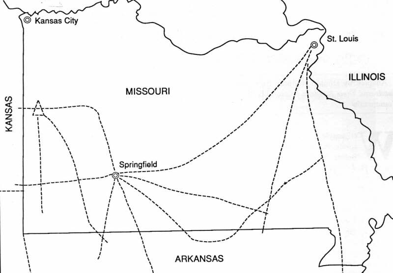
Sketch map, approximate routes of Osage trails.
About 1828, Thomas James, along with Samuel Massey and more than one hundred laborers, started erecting the Meramec Iron Works. By 1837 wagonloads of iron were rolling to many parts of the state, with much of it freighted overland to St. Louis, and supplies for the mines came back the same way. Three years after James began erecting his ironworks, in 1831, two post offices were operating in the area--one at Piney, about ten miles southwest of present Rolla, and one at Meramec. The white man's needs were solidifying his use of the old Indian trail and making it a road.The other end of the old trail was going through the same evolution as settlers penetrated into southwest Missouri along the White River. Legal complications, however, slowed the development of the area.
The U.S. Government had granted reservations in the area to the Delawares in 1818 and to the Kickapoos in 1819. These tribes started occupancy about 1822 -and, of course, found themselves confronting white settlers who had pushed up the White River and along the trail itself to the Springfield area. The government finally upheld the Indians' rights, and the white settlers moved out, some to the already established settlements on the Meramec and Gasconade headwaters. But for the Kickapoos and Delawares, the victory was only temporary. In 1832 they ceded their claims to the United States, and many of the early white settlers returned to make their homes there.
White settlers into southwestern Missouri, like others elsewhere in Missouri and Arkansas, came from many points east, but especially from southeastern states. As the frontier advanced, they moved with it, as did old Squire Ezekial Hagan. He had moved from Virginia to western Carolina and then to Tennessee, and when land hunters came in with good news from Arkansas and Missouri, he planned to "git on."
The whole southwest Missouri region was "gittin' on," too. Greene County was organized in 1833. By 1835 a land office was opened in Springfield, on its way to becoming the largest town in the region and important enough to demand state attention. A state road was authorized from St. Louis to Springfield, with the authorization coming in sections. The first legislation was approved February 6, 1837. By then immigrants into the region were flocking over the new road--that old Osage trail--and its niche in the history of Missouri transportation continued, as it still does.
Early settlers had called it the "Osage Trail" or the "Indian Trail." Later it was called the "Kickapoo Trail." But the white man's stamp was marked indelibly on it when it became know as the "old Springfield road" or the "St. Louis-Springfield road." Progressing through various names and numbers, it became the fabled U.S. Route 66 of story and song. And today, in the latest stage of its evolution as Interstate 44, it serves all Americans' intrastate and interstate needs as it once did the Osage.
[2]
Other Indian trails, although some of them were known by white European names, became other highways. Along Virginia's Warrior Path, U.S. Highway 60 was built across south Missouri from Seneca to Poplar Bluff. Franquetin's Trail became U.S. Highway 63 from Arkansas to Jefferson City. Smith's Trail led from Jefferson City to Keokuk, Iowa, and became U.S. Highways 54 and 61. DeSoto's Trail along the Mississippi River from deep in Arkansas to Saint
Louis became U.S. Highway 61, and then Interstate 55. Du Tisne's Trail from Rolla to Flat River, Missouri marks the route of Missouri Route 8. Saint Michael's Trail, Natchitoches Trail, and Shawnee Trail provided directions for other Missouri highways and railroads in southeastern Missouri. In northern Missouri, rail and county, state, and federal roadbeds follow Bourgmont's Route, the Great Trail, and Field's Trace to The Village of The Missouris in their treks from Saint Louis toward the Upper Missouri River and the Great Plains.
Copyright -- OzarksWatch
Next Article | Table of Contents | Other Issues | Keyword Search
