 |
Vol. VIII, No. 4, 1995 |
A Place of the Heart
by Suzie Rogers
The Buffalo River Valley is a place of the heart to those who have known it. Its hills, hollows and tributaries nurtured and nestled pioneer settlers in snug coves and sheltered valleys where the fabric of life was pieced together, like a well loved quilt, among a known group of family and friends. It was not an easy life. Many settlers finally headed north or west, to more level, more fertile soil. Those who stayed tied lasting bonds in their small community areas. Their descendants, even those who had left the Buffalo behind years before, suddenly would find an urge come over them to go "down on Buffalo" one more time.
The people of the Buffalo were an independent, stubborn lot. One had to be in the 1830s, to carry families across the continent to land you couldn't even purchase as your own (public land surveys didn't begin until the 1840s). They came from various stock. Most were Scotch-Irish and brought with them the traditions of the southern Appalachian Mountains. Some were of mixed blood, intermarried with the Cherokee who shared their homeland in North Carolina and Tennessee. A few came from unique settlement patterns, such as the French Huguenot Villines family. These settlers knew how to live on their own, to use the Ozark mountains literally for food and hearth. The virgin cedar and oak trees provided logs for their houses; the range of edible and medicinal plants got families through illnesses, or destitute times like the Civil War. They knew how to work hard; hand clearing fields of heavy vegetation and Ozark mountain rock not only was a hard job, but a repetitive chore. Legal claim to the land need only be made at the land office, and made once, but the claim against mother nature had constant due.
The fertile bottomland fields of the Buffalo itself and its tributaries were the earliest settled. Here, the Buffalo's unpredictable waters gave welcome watering or devastating flooding to family corn and wheat fields. Homes were usually built above the last bottom and near a spring; for some people, being away from the dampness of the river valley prevented disease. Hogs ran "on the mast" to fatten up; paling fences protected home yards from their wanderings and rail fences kept them out of fields. A few cows, maybe an ox, and horses or mules for riding or plowing completed the family farm. After the flood plain lands were claimed, open "benches" on the high slopes were cleared and fanned. Many of these skytop clearings are still in use, commanding some of the prettiest views on the Buffalo.
Until the Civil War, the population along the rich river valley steadily increased. Homes were constructed, land cleared, schools and churches established. During the Civil War, the constant conflict between Union and Confederate supporters, both as organized troop actions and disputes between families at home, resulted in a landscape which had to be rebuilt, but the tenacious Buffalo River pioneers did just that. Using the free entry land of the Homestead Act of 1862, sons and daughters of the original pioneers established their own family farms. And, to add to the original farmers came families from northern Iowa and Illinois, and families from southern states, like Alabama and Texas. Some moved on again, but those who stayed developed not only prosperous farms, but community areas where neighbors could meet, go to school and church, trade, and be buried. T he communities of the late nineteenth century became the local social and commercial centers.
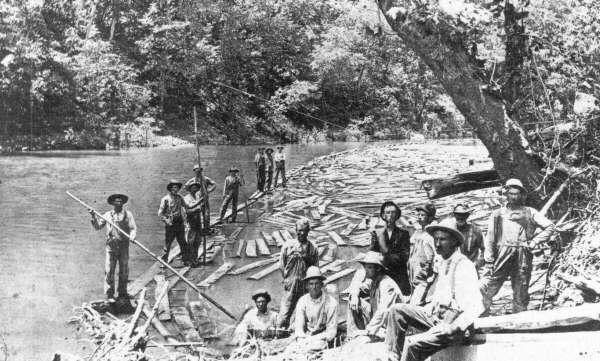
Rafting logs on the Buffalo.
Photo: Courtesy of Stella Mason.
[1]
They were more important in the lives of local families than county seat or state capital. Some people never got farther -- or wanted to -- than these community areas. Churches and their strong willed preachers provided rules for life as well as strength of faith; marriages began here as young people courted during sup-per-on-the-ground or a young man saw his best girl home after meeting. Rural schools, worked around the demands of planting and harvest, taught team work and responsibility as well as the three R's. Stores were more than goods: the post office was here; stores were meeting places; sometimes marrying places if the storekeeper was also the Justice of Peace; feuds started, and sometimes ended here. Homes, too, became centers for community get-togethers; furniture was pushed back against the wall while dancers swung to the tune of a master fiddle player.
The family farms along the river and the communities they supported became the "map" for those who traveled the river valley. As families changed, so did some of the river names, but the meaning was clear -- these are our places. The names we still use for the places of the valley are the lasting memory of these people, in river bend or bluff, river access point, tributary: Tyler Bend, Grinders Ferry, Rose Ridge, Steel Creek, Cecil Creek, Baker Ford, Erbie, Mt. Hersey, Maumee, Pruitt.
A major upheaval to the Buffalo River valley came in the years surrounding World War II. Many family members left the valley and never returned, finding employment in larger towns like Kansas City, or faraway states like California or Washington. School consolidations and post office closings, mandated by decisions made elsewhere, began to change the community nature. (Even in the nineteenth century families had taken houses in town so children could be nearer schools.) The
community hub diminished as trade centers moved to the county seats. Local grist mills ground more slowly, and finally not at all as folks took their grain to Valley Springs or Harrison. In the
old mining town of Rush, storekeeper Lee Medley hoisted a sign advertising "Rush Ghost Town" and spun his tales for fishermen and rockhounds. Farms were rented out. Row crop fields were consolidated into large hay pastures. Old dwellings became hay barns. Seasonal recreational
homes and cabins began to be visible along the river. The cultural significance of the Buffalo River valley is not just individual buildings, but the whole tapestry of homes and fields and fences and
river crossings and community sites. This landscape has survived for a number of reasons, but one reason is that here the past has always been part of the present. (This is not to say that the people
of the area aren't forward looking citizens, because a good number of ideas and industries began here -- but one can't help but appreciate an area which hasn't needed stoplights.) Topography defined community areas and access to those areas, a fact which still restrains "urban sprawl." In addition, Buffalo River residents were a thrifty bunch, who knew good management meant getting full use from still good items. Although some folks replaced log homes with ones of sawmilled
lumber, other families simply framed over the well-constructed log exterior and added on more rooms. Unused outbuildings were adapted as farming and family needs changed. It's not
uncommon to see old homes, and even one-room schools, strewn with the remains of stored hay. Old yard pickets made dandy repair material for a barn loft. Many thin-walled Buffalo River
homes were insulated with layers of newspapers and magazine pages. "You spent the winter
reading your walls!" reminisced one former resident. Today we search among those peeling
remnants for a dated page to help us place the structure in a time frame.
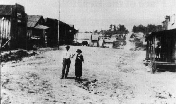
Main Street, Gilbert, 1923
Photo: Courtesy of Ray Jordan.
[2]
Identification, documentation, and preservation of this cultural landscape was in Buffalo National River's mandate from the earliest park planning discussions and still continues. Five park areas have been identified as significant examples of Buffalo River settlement. These are: Rush (mining history); Erbie (early pioneer settlement); Boxley (vernacular and ethnographic landscape); Collier Homestead (20th century settlement); and Buffalo Point (CCC contribution). All are eligible for or are on the National Register of Historic Places.
Agricultural use continues along the river, too. About 5800 acres of parkland are actively farmed, in private use zones like Boxley and Richland, and in special permit areas throughout the park, where today's farming continues a pattern begun 150 years ago or more. Visitor facilities, such as those at Erbie and Tyler Bend, are set in the midst of still productive hay fields.
For me, some of the most special of the park's historic resources are found in the out of way places of the park. Lost on the riverbank is a small stone springhouse. In winter, remnants of a paling fence appear out of summer's tangle. A hand-split shingled roof still graces a barn now enshrouded by trees. A gravestone in a small family cemetery honors a son lost to Union bullets in a valley encounter during the Civil War.
One of these special places is the Eva Barnes Henderson farm on Sneeds Creek in Ponca wilderness. Sneeds Creek empties into the Buffalo just above Hemmed-in-Hollow, a popular destination in the park. Illustrative of many Buffalo River farms, the Henderson home, now enclosed in a designated wilderness area, is as isolated today as it was during early pioneer days, assessable only by foot or horseback, or from the river.
The centerpiece of the riverside farm is a fine frame house in traditional style. Also on site are an old log house recycled years ago into a barn, hog sheds, chicken coop, dug cistern, fruit cellar, paling fence, and still-producing fruit trees. Water came from a spring near the river, hauled by hand, even in the 1970s. No electricity made it this far. But this house, and its neighbor up the creek, the Evans-White house, were stopping points for travelers on the roadways which connected the residents of the upper Buffalo region.
Frank and Eva Henderson made their home here with their daughter Arbie. Arbie, an only child, married and raised nine children, eventually moving farther up the mountain. Eva Henderson was widowed in 1959, but stayed on the place she knew best. She became well known to area visitors, who got used to calling her "Granny." In 1977 she was featured in a National Geographic article on the Buffalo River. Eventually, her health failing, and with land being purchased for the newly established Buffalo National River, her grandchildren persuaded her to leave. Reluctantly she agreed ("she had a head of her own," said her daughter). She died that same year in 1979. For the past couple of years, daughter Arbie, now 85, together with her children and grandchildren, have taken an autumn raft trip down the Buffalo to visit her old home.
The Henderson farm sits vacant now. Cedars have reclaimed corn fields along the river. The log barn has collapsed, as have other outbuildings. The house still stands proudly, and on the doorway, in tribute to Granny, an unknown visitor has attached a decopauged copy of the National Geographic article. To a few, the decaying farm is an intrusion on the wilderness setting. For most viewers though, the farm represents the challenges and solutions of pioneers of the Buffalo. It is the spirit of Eva Henderson and many others like her for whom "place" was more important than "things." And that place was the Buffalo River valley of their community neighborhood. The Henderson home, like several other homesites along the Buffalo, will continue to be preserved as part of the still living history of the park. Recently, to the dismay of those who love this old home, vandals used the house for a message board, painting "Mark Jessel Go to Kyles" on the exterior. Too bad that these folks didn't know how to show respect for the history of the valley, to sit on the porch, feel the breeze from the river, and share the spirit of generations who could have spoken to them if they had bothered to listen.
[3]
Copyright -- OzarksWatch
Next Article | Table of Contents | Other Issues | Keyword Search
