 |
Vol. VIII, No. 4, 1995 |
Special Places
by Jim Liles
There have always been places to grow crops along the Buffalo. The sheer bluffs and hillsides which squeeze the river don't yield much farm land, but from pioneer times on, determined farmers have found ways to wrest a living from ridgetop, benchland, and river bottom.
This general scarcity of cropland makes two river valleys special --- Boxley, along the upper Buffalo, and Richland, on the long tributary creek of the same name that flows into the Buffalo about midway of the river's length.
Jim Liles is Assistant Superintendent of the Buffalo National River. He has particular responsibility for coordinating land use management in the two valleys he writes about.
Richland Creek is the longest of the Buffalo's tributaries, beginning some 32 miles south at the southern extremity of the Buffalo River water shed. Much of the Richland valley would have been submerged had the two high dams across the Buffalo proposed by the Corps of Engineers been built
No matter, some might say. By the 1950s, only a few families lived in the valley, which had declined from a prosperous farming community over the first half of the 20th century.
Some might contend that the only adverse impact would have been the flooding of the Hall Cemetery where rest the bones of those who lived out their lives.
In the land of living waters
where the mountains are covered with wood,
Where cows lie down in green pastures
and proudly chew their cud.As you stand upon the Narrows,
and see the cotton fields below,
You can scarcely believe your eyes-
it looks like afield of snow.
-- poem by Waldo Fowler, raised in Richland Valley.
With the decline of the two big cash crops, (timber was logged out and too many decades of cotton had depleted the rich Valley soil), and the lure of job opportunities "out west,"the Valley's once--considerable population died or drifted away. When the Valley's several one-room schools closed at mid-century, the last few families moved closer to the town of St. Joe, so the kids could go to school there without having to cross the unpredictable Wollum Ford over Buffalo River at the mouth of Richland Creek.
There was only one landowner of note on lower Richland Valley at the time the idea emerged to save the Buffalo River (and lower Richland Valley) from being buried by the Corps of Engineers. The one landowner was Lunceford Cash. "Lunce," as he is known by everyone for miles around, is descended from such pre-Civil War settlers of Richland Valley as Jack Hensley, who died while a prisoner of war in St. Louis. Lunce's grandfather, Jim M. Cash, was notable for having had six successive wives (seven if you count again the one he married twice). Before he died in 1966, Lunce's father, "Em" Cash, acquired most of the upper Richland bottoms. He passed them on to Lunce, and asked to be buried up the mountain in the Love Cemetery, rather than down in the Hall Cemetery, as all the talk was about the big dam coming that was going to flood the valley and Em sure didn't want to spend an eternity under water.
[8]
Fortunately, Congress established the Buffalo National River to be managed by the National Park Service. Today, all of lower Richland Valley (the four miles lying within the Park), is once again green pastures. It is owned by Lunce and farmed by him and his son Fon Cash, whose family is the only one in that lower stretch of the valley. The National Park Service owns an easement that requires that the land be used as it always has been, maintaining the pastoral landscape.
The infrequent visitors to the Valley cross Rollins Mountain from Snowball, Arkansas, through McCutcheon gap, near St. Peter. They drive, walk or ride the same one-lane farm road as was used by the 101 Union soldiers guarding the Federal supply train moving up that road in May, 1864. Half their numbers were killed or wounded in a surprise attack by an independent company of Confederate soldiers. The several wagon loads of ammunition never made it to re-supply Union forces on the Tennessee battlefronts. Unfired musket-balls were plowed up for many years from the fertile soil of Richland Valley.
That same narrow road through Richland Valley was the scene of a much bigger gathering of wagons (more than 200, according to oral history), in January, 1880, with the first cooperative effort by farmers in the vicinity to get their produce to market in Russellville, 80 tortuous miles to the south.
Today, the National Park Service manages Richland Valley as a private use zone. Like Boxley Valley the land remains in private ownership, subject to Park Service restrictions for the protection of natural and cultural resources. Although both valleys are cultural landscapes created by over 150 years of cultivation and modification by the hand of man, the striking difference between the two valleys today is that most of the people are gone from Richland Valley, while Boxley remains a lively community. Its road is paved and bustling with traffic; its roadside homes lived in and well maintained.
All that remains in Richland to suggest a place once similarly vibrant with human life are the graveyards and ruins of long-vacant houses. The Masonic Hall Cemetery is among the most evocative cemeteries along the Buffalo River, where headstones, elegant or faceless, whisper the names of the long-departed souls. A few structural remains hint at the Valley's former prosperity. Three old frame houses built early in the century by families named Franklin, Cash, and Watts, may stand a few more years against the ravages of time, weather, and vandalism. Only chimney ruins remain to mark a few other homesites. Three old barns remain, plus the stone pillars of a fourth which once housed a mule or horse-powered cotton gin. The only log structure remaining is a little smokehouse on the former Tip Treadwell farmstead.
Perhaps more so than at any time since the arrival of man (archeological investigations indicate more or less continuous occupancy of the valley from ca. 3000 b.c.), Richland Valley is now a place of serenity and solitude -- a place to contemplate its heritage from the tantalizing remains of its past.

Photo: Courtesy Buffalo National River.
[9]
Beautiful Boxley
This little valley is a product of geological happenstance. It came about as a result of at least three coincidences:1) Its seven mile length collects the converging flows of ten steeply-pitched, high-energy tributary creeks;
2) It is located among the highest hills of the Ozarks, some 20 miles downstream from the headwaters of the upper Buffalo River; and
3) It is situated over a zone of particularly flinty limestone bedrock, more resistant to erosion than the beds above, through which the upper fiver had cut its channel.
Upon reaching those resistant beds of rock, at an elevation above sea level of about 1140 feet, the fiver flattened out to a gradient of only about 17 feet per mile, though it descended the preceding five miles at a pitch almost double that.
During high water run-off all the converging creeks, as well as the upper Buffalo River itself, were laden with the products of their erosion and energy --silt, sand, gravel, cobbles, and even boulders. In flood, the waters above the valley moved that burden easily along -- smaller particles in suspension, larger ones bouncing and rolling along the streambeds. Over the rollicking fiver miles, the bigger stones were broken into smaller ones, and the resulting gravel worn smooth by abrasion with one another and with creekbed rocks. When those ten creeks and the upper Buffalo reached the little valley, their waters slowed and began to drop their burden of rock debris. Over the millennia, the fiver coursed back and forth between the confining valley sides, spending a few hundred or thousand years on first one side and then the other.
The valley became a catch-basin for the river's sediment. Distributing a vast amount of alluvium over time, the river has produced a valley, deep-soiled and a half- mile wide, that runs from the foot of the east slope of Cave Mountain for seven miles, almost to Ponca Creek.
The remaining 122 miles of the Buffalo River has no other place equivalent. The little valley has sheltered plant and animal life for an incomprehensible span of time. Some 10 to 30 thousand years ago, the roars of great mammals now gone from the earth echoed from the flanking hillsides. The fossilized bones of 24 extinct species of animals, including three-toed horse, saber-toothed tiger, and musk ox have been excavated from pits near the Buffalo River, not far below this valley, and from further down river, remains of mastodon and mammoth have been found.
Perhaps as long as 10,000 years ago some human newcomers passed through the valley following roving game. In time, these hunters surely came to value this particular river valley as a good place for a seasonal or even a permanent camp. To make clearings for planting maize and such vegetables as were eventually cultivated by these early people, all that was required was to burn off the fiver cane. The cane itself was handy for weaving a thatched roof for temporary shelter, and natural shelter was available on either side of the valley, where the river and its side-creeks had carved bluffs, some of which reach several hundred feet high and are imbued with overhangs and coves. One such spacious "rock house" graces the northwest side of this valley, a couple of miles up a tributary creek from the river. The valley's creeks sustained a mix of aquatic life, and the forest was home to a rich variety of game, including buffalo, bear, elk, deer, turkey, and all manner of smaller birds and animals that contributed to the Indian diet.
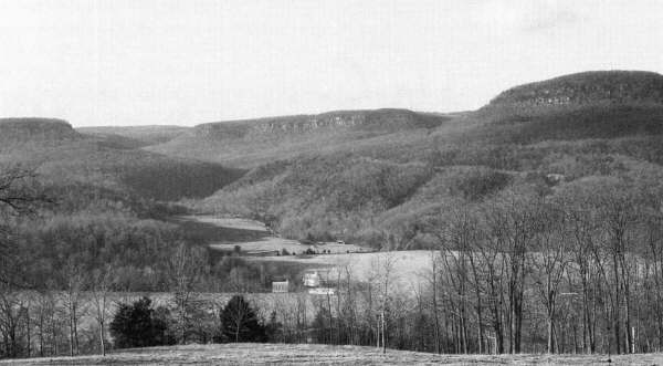
Photo: Courtesy Buffalo National River.
[10]
The benched slopes above the valley were forested with many trees and shrubs that provided nourishment -- especially the fruit of several species of oak and hickory, as well as walnut, plum and persimmon. Throughout the valley can be found dozens of flat rocks, each hollowed by the mano stone used by early inhabitants to grind corn or acorns, preparatory to leaching out their bitter tannins to make them palatable. (Those "grinding trays" now serve as birdbaths and chicken feeders decorating yards and paths.)
The Valley has had essentially continuous human occupancy over an impressive span of time. Hard on the heels of the last hunters and gatherers to vacate the Valley came the first wave of new arrivers from the east -- the settlers. By the 1830s, settlers of European origin were on the move west. Some, many from Kentucky and Tennessee, discovered the Valley -- and a few liked it well enough to stay and multiply. They built homes and barns and gristmills and churches. Many of the families who still live in the Valley are descendants of these pioneer settlers.
One of the important goals of the National Park Service is to maintain a community of residents in the Valley, preserving that community's special character and sense of place, while managing to accommodate appropriate change. To help accomplish this goal, much of the land in the Valley has been returned to private ownership or leasehold, subject to certain restrictions required by the Park Service.
The river continues to run, erode, and carry the earth to the sea. Each passing year brings changes to the Valley: changes in vegetation; changes in the fiver channel and bank; changes in the amount of traffic on the high-speed highways coursing through the Valley; and, most unpredictably, changes in the human face of Boxley Valley. As old-timers pass on, their offspring grow up to take their places. And as land is sold, families will move away and new ones arrive.
The physical landscape will change. A few new homes will be built from time to time and, regrettably, historic structures will suffer attrition over time. Barns built 50 or 100 years ago to stable horse, mule, or milk cow are not readily convertible to modem use, and may be neglected.
There will be changes in the cultural landscape as land uses gradually modify and the old ways of doing things fall out of fashion, or people simply forget (or choose not to make the effort) to butcher hogs and cure hams. Or reduce sorghum cane to molasses. Or hitch a mule or draft horse to a plow to break the garden sod. The pasture forage of choice will no doubt change, as it changed from native to exotic grasses during the last century, and to the now-predominant fescue in the 1940s. Who knows?, the production of hay and grazing of cattle may cease to be the dominant land uses, as meat makes up less of America's diet.
The river flows on, rising and falling with the seasonal rains, overflowing now and then to cover much of the Boxley Valley bottomland, and leaving behind an annual increment of revitalizing silt and organic debris. Pasture fences are periodically pushed askew by the flooding river's force, banks undercut and trees uprooted -- all part of the age-old process by which the valley itself was created. Man works his hand at holding the fiver back, mostly to no avail. Those whose grandparents dealt with the fiver and drank it in with mother's milk, seem to know how best to coax and nudge and mollify the flooding waters. They stoically and repeatedly mend the flood-damaged fields and fences. They know that the river gives and the fiver takes away -- year after year after year.
[11]
Copyright -- OzarksWatch
Next Article | Table of Contents | Other Issues | Keyword Search
