 |
Vol. IX, No. 3, 1996 |
The Bull Shoals Dam
by Glenn Johnson
This article has been adapted from History of Marion County, edited by Earl Berry, and published by the Marion County Historical Association, 1977
Any discussion of the reason for the construction of the Bull Shoals Dam must begin with a review of the frequent and devastating floods that occurred on the White River and its tributaries in the first quarter of the 20th century. Floods had occurred from time to time prior to August of 1915, but in August of 1915 the flood waters of White River reached an all-time high--even higher than any prediction. Farmers had produced bumper crops all along the river, and harvesting was scheduled to begin in about a month when the flood came. Most crops were almost a total loss; livestock and property damage was high---estimated in the hundreds of millions of dollars. Loss of life was heavy also. In 1927 an even more destructive flood, with flood waters even higher than those in 1915, plagued the people of the White River Valley.
The people realized that there was little that they could do as they had no control over the rainfall and, at that time, no way of regulating or controlling the runoff from the rainfall. The problem was not limited to the White River alone, but many other rivers in various sections of the country were flooding urban areas as well as farm lands. The United States government recognized the need for Federal action, and the task of regulating and controlling the stream flow from the rivers was assigned to the U.S. Army Corps of Engineers. Many of the men in the Corps of Engineers had seen service in Europe during World War I and had observed the dams on the rivers in Europe. They had the technical training, experience, and know-how to begin a systematic study of the rainfall over a period of years and to determine how floods on these rivers might be controlled. A comprehensive study of the Arkansas River and the White River in Arkansas led to a voluminous Report and Recommendation by the U.S. Corps of Engineers to the President and to the Congress that a series of flood control dams be built along these rivers and some of their tributaries.
[15]
The Report and Recommendation was received by the Congress and several of the proposed dams were authorized. But an authorization by Congress without an appropriation of funds for the construction was a meaningless gesture. Congress did appropriate some money for construction, but in the early years the amount appropriated was sufficient only to make preliminary studies pertaining to location, type of dam, flood damages, cost of construction, and estimated benefits to be derived therefrom. Congress was concerned with the cost-benefit ratio, and while it favored construction, the Study seemed to indicate that in some proposed dams the benefits from flood control alone did not offer a satisfactory cost effect. This situation led the Corps of Engineers to further their study to include dual-purpose dams -- dams built primarily for flood control but with hydro-electric facilities and recreation as secondary benefits.
There were many individuals all along the Arkansas and White Rivers who devoted their time, their energies, and their finances to keep before Congress the necessity of appropriating the funds for construction of the authorized dams. It can be said to the credit of the entire Arkansas Congressional delegation of the late 1920s and into the 1930s that they favored the authorization of the flood control projects and voted for appropriating the funds necessary for construction.
With the proposed addition of hydro-electric facilities in the dam, the question arose as to how the electricity produced at these dams would be marketed. Two ideas for the marketing were advanced: first, that all power generated at the power plants operated by the Corps of Engineers be sold at the bus-bar to the private power companies to be used in their transmission and distribution systems; second, that the government itself would market the power, giving priority to public bodies, municipalities, governmental installations, and electric cooperatives. The surplus, if any, would go to the private power companies.
These proposals brought on a division among the proponents of the flood control dams--and also led to a difference of opinion among members of the Arkansas Congressional delegation. It might be well to point out here that the Congress itself was highly divided on that issue. Senator George Norris of Nebraska was the chief advocate of the public power group. Representative John Rankin of Mississippi carded the fight for public power on the House floor. A majority of the Congress early seemed to favor the idea of selling energy to the private power companies. In connection with public power marketing, the chief support came from the Pacific Northwest, Nebraska, and states in the newly-created TVA or Tennessee Valley Authority. Rumor had it that President Franklin D. Roosevelt, in his first term as President, had proposed the creation of an Arkansas Valley Authority instead of a Tennessee Valley Authority for complete harnessing of all the resources of the Arkansas and White Rivers, but then-Senate Majority Leader Joe T. Robinson favored distribution to the existing private power companies and the matter was dropped.
In 1938, although authorization had been made for construction of the Norfork Dam as a flood control project, no actual construction had been undertaken. In the congressional campaigns in Arkansas in 1938, a young attorney from Bentonville, State Senator T. Ellis, Clyde became a candidate for Congress for the Third District. He made as a chief campaign issue cheap electricity for every home and the installation of hydro-electric facilities in every flood control project where economically feasible. He was elected to the Congress and began his first term in January 1939, along with three other freshmen congressmen from Arkansas--Wilbur Mills, "Took" Gathings, and William F. Norrell.
In Congress, Mr. Ellis, with the help of some of the Arkansas delegation and the help of Senator
Norris, John Rankin, and others, made a successful fight to have power facilities installed in the
Norfork Dam. Later, with the support of many others in Congress, power facilities were
authorized for Bull Shoals, Table Rock, Beaver, and Dardanelle, as well as at the Narrows Dam,
Blakely Mountain, and at Greer's Ferry.
[16]
Citizens of Baxter, Boone, and Marion Counties and groups of interested citizens from Springfield and Branson, Missouri played an important role in convincing the Congress and the Corps of Engineers that power facilities should be installed at the flood control projects. This was not an easy task, because the private power companies, fearing that the electric energy generated at these projects might not be available to them for their own customers, launched an all-out advertising campaign calculated to convince Congress and the general public that no additional power-generating facilities were needed anywhere in Arkansas, and that there was, in fact, a surplus of power. The companies could and would, they argued, construct from time to time facilities as needed and thereby save the government needless expense and extravagance. Since the companies were able to buy full page advertisements in local newspapers and had successful lobbyists in Washington, most, though not all, newspapers and many Congressmen agreed with their arguments.
Early in the discussion it became apparent that Congress wanted an expression from the people directly affected by the dams about whether they desired flood control only or dual-purpose dams. The Corps of Engineers arranged for a series of public hearings at various towns in the area, and citizens were invited to appear to present their views on whether or not the dams should be built and their views on whether or not they should be built as flood control projects only or as multi-purpose projects. Such meetings were held at Newport, Batesville, Harrison, Mountain Home, and other locations.
Opinions and ideas were not unanimous. In fact, many opposed the dams for any purpose. It was said by some: "The man above the dam didn't favor a dam. The man below the dam favored it. The man at the dam didn't give a damn." In general, the majority of the people in Baxter, Boone, and Marion County looked with favor upon construction of the dams and many favored multi-purpose dams.
Among the most ardent advocates of multipurpose dams on White River was the late Judge
R.M. Ruthven of Baxter County. He would recite the undesirable features of flood control-only
projects and cite the Wappapello dam on the St. Francis River in Missouri as an example of the
mud, filth and slime that followed a flood when the water receded. He would point out that the
farm land could not be cultivated and the water in the reservoirs would be of little value for
recreational purposes. Another ardent advocate of multi-purpose dams was Mr. Tom Shiras,
editor of the Baxter Bulletin, who said that there were millions of wild horses running untamed
and unhamessed down White River doing untold damage, bringing death and destruction to the
people of the White River Valley. He concluded his plea to Congress, "Tame and harness these
wild horses and put them to work for the people whose property they have destroyed."
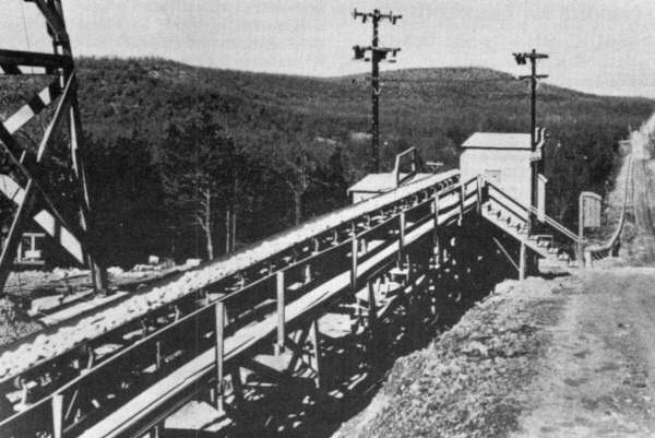
The seven-mile-long conveyer belt used to carry crushed rock from a quarry near Flippin, Ark. to the Dam site.
[17]
Schoolcraft Encounters the Bull Shoals on White RiverArkansas was just emerging as a separate territory carved from the Missouri district of the Louisiana Purchase when Henry Rowe Schoolcraft ana his travelling companion Levi Pettibone encountered that part of White River which would later become part of Bull Shoals Lake. Tuesday, Jan. 12th (1819) In our descent this day, we have passed several hunter s cabins on both banks of the river, but met nothing worthy particular note until our arrival at the Bull Shoals, situated twenty miles below M'Garys. Here the river has a fall of fifteen or twenty feet in the distance of half-a-mile, and stands full of rugged calcareous rocks, among which the water foams and rushes with astonishing velocity and incessant noise. There are a hundred channels, and the strange navigator runs an imminent risk of being dashed upon the rocks, or sunk beneath the waves, whose whirling boiling and unceasing roar warns him of his peril long before he reaches the rapids. There is a channel through which canoes or even large boats pass with a good depth of water, but being unacquainted with it, we ran the hazard of being sunk, and found our canoe drawn rapidly into the suction of the falls, apprehensive of the result. In a few moments, notwithstanding every effort to keep our barque headed downwards, the conflicting eddies drove us against a rock, and we were instantly thrown broadside upon the rugged peaks which stand thickly in the swiftest part of the first schute, or fall. Luckily it did not fill, but the pressure of the current against a canoe thirty feet in length, lying across the stream, was more than we could counteract, and we had nearly exhausted our strength in vain endeavours to extricate and aright it. For all this time we were in the water, at a depth of two, three, and four feet, at a cool January temperature, but at length succeeded in lifting it over a ledge of rocks, and again got afloat. We now shot down the current rapidly and undisturbed for 600 yards, which brought us to the verge of the second schute, where we twice encountered a similar difficulty, but succeeded, with alogous efforts, in passing our canoe and effects in safety. From Schoolcraft's Ozark Journal 1818-1819. Reprinted in Rude Pursuits and Rugged Peaks, University of Arkansas Press, Fayetteville. 1996 |
After the Public Hearing by the Corps of Engineers, a recommendation was submitted to the Congress that the dams be constructed primarily for flood control with production of hydro-electricity and recreational facilities where desirable and economically feasible.
Upon learning of the recommendation, Congressman Clyde T. Ellis asked for and received the approval of the Congressional Committee considering the matter to have delegations from Baxter, Marion and Boone Counties to appear before the Committee to voice their views on installation of hydro-electric facilities in the Norfork Dam soon to be under construction and for the other dams to be constructed later on White River. Delegations from these counties and other areas did go to Washington and appeared before the Committee.
Construction of the Norfork Dam began the following year with power facilities included. With construction of Norfork, the economy of both Baxter County and Marion County was changed. Many men in Marion County were employed on the Norfork project, and this employment gave them the experience needed to qualify for better jobs on many war projects that sprang up all over the nation when we were engulfed shortly thereafter in World War II.
Soon after World War II ended, construction on the Bull Shoals Dam began. Many of the men in Marion County had been employed in various war-related projects which were now closed, and many returning veterans to Marion County found no jobs. The building of Bull Shoals Dam was a life saver for the economy of Marion County. Men found employment here in the county. New businesses sprang up in Yellville and Flippin. A new town--Bull Shoals-- came into being. The need for new homes and additional housing became apparent. Construction of these followed both in the towns and in the areas surrounding the towns. A paved highway from Flippin to the dam site was constructed as was a highway from Highway 5, at Midway in Baxter County, to the dam.
With these roads built, it became apparent that a bridge across the top of the dam was a necessity but such had not been provided for in the appropriation. The Arkansas Congressional delegation was contacted and through their cooperation and that of the Arkansas Highway Department, the road from Flippin to Midway was made a state highway with a bridge across White River at the dam.
[18]
Many problems arose in the county as a result of the building of the Bull Shoals Dam. Among these problems was the relocation of life-long residents of the valley who, as the reservoir began to fill up, were obliged to leave their farms and relocate. In many instances this meant leaving Marion County as there was not enough fertile land in the county to take the place of the river bottoms and creek bottoms which they had farmed. Another problem was the relocation of the roads and bridges which had been inundated by the reservoir. That part of Marion County north of White River, including Northfork Township, Cedar Creek Township, and Keesee Township, were isolated from the remainder of the county as there were no bridges or ferries across the lake by which the residents could reach Yellville (the County Seat). One of the most emotional problems that arose was the removal of the remains of loved ones buried in the cemeteries that would soon be inundated by the reservoir. Many cemeteries were relocated and remains from some cemeteries were taken to nearby already existing cemeteries. This was a tedious and time consuming project, but due to the understanding, courtesy, and cooperation of the Corps of Engineers and the contractors who did the work, no serious problems developed. Among the cemeteries relocated, perhaps the largest one was the Wild Cat Cemetery which was relocated on the highway near Fairview and renamed the Fairview Cemetery.
Another problem that arose was the damage to buildings in Flippin and the area near the rock quarry located on the Wilson farm on Lee's Mountain, brought about by the heavy blasting at the quarry. Damage was extensive and practically every business building in Flippin and many of the residences suffered damages to a greater or lesser degree.
It was necessary for the Corps of Engineers to secure title in the name of the United States Army Corps of Engineers to all land to be inundated by the reservoir at its predicted highest level and an additional narrow strip above this level. This was an arduous task as the title to each parcel taken had to be examined, the property appraised, and an offer made to the owner. If the offer was unacceptable and an agreement to price could not be reached, condemnation proceedings were instigated under the government's power of Eminent Domain. The next step was a trial in the Federal District Court in Harrison. Often the judgment rendered as to the value of the property taken was not satisfactory to either the government or the property owner but few appeals were taken.
The construction was delayed somewhat by floods that occurred, and by a "wild cat" strike. This strike was not settled for some time, but it did not stop work altogether.
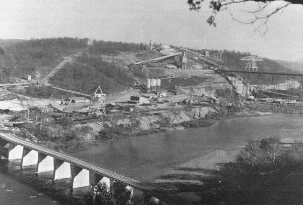
An unusual feature in the construction of the project was the seven-mile conveyor belt line built to move crushed rock, to be used in the concrete, from the quarry on Lee's Mountain, just northwest of Hippin, to the dam site. At the time it was built, it was reported to be the longest conveyor belt system ever built for such a purpose. To transport the aggregate to the site in the conventional way would have required a steady stream of trucks bumper to bumper, working full time traveling to the dam and back. The conveyor belt method of transportation received both national and international attention and was the subject of many articles in magazines and professional journals.
The dam was completed in 1951, and the huge reservoir behind the dam began to slowly fill. About this time, stories of reported leaks in Bull Shoals Dam were circulated, but such reports had been heard earlier relative to Norfork Dam.
The Corps of Engineers, however, confirmed that there was a leak, although it was not in the dam itself. They could not, at the time, locate the leak nor explain it.
One of the unusual situations that first attracted attention was a change in the flow of water at the Due Eddy Spring located about one mile below the Bull Shoals Dam on the Baxter County side of White River. As the Bull Shoals reservoir began to fill, a noticeable increase in the flow of water at the Due Eddy Spring was observed. By the time the reservoir was full, the flow of water at the spring had increased to several times its normal flow.
The Corps of Engineers began a series of drilling tests on three sides of the spring in an effort to determine the direction from which this additional flow was coming. They found that the pressure of the increased flow was terrific, with a constant boiling action that brought small stones to the top of the water, but they were unable to determine the direction from which this increased flow came.
Then in 1954, as the water level of the lake declined due to a prolonged drought, reports circulated to the effect that water was running into holes along the shore line of the Jimmies Creek arm of the lake on the farm formerly owned by Simon Osborn. These holes were twelve to fifteen shore line miles above the dam and three or four miles west of the Due Eddy Spring and on the opposite side of White River. Fishermen reported that they had found a place on the shore line where the water was flowing out of the lake into a hole and that they could hear the water falling as over a waterfall. The Corps of Engineers investigated the report. It was found to be true.
Following the investigation, the Engineers poured colored dye into the hole where the water was leaving the lake to determine where it would surface. The next day traces of this dye appeared in the flow of water at the Due Eddy Spring. This water had to flow under part of the lake, under a state highway, under Bull Shoals Mountain, and under the White River--a distance of some three or four miles--to make its appearance in the Due Eddy Spring.
The Corps of Engineers conducted a study to ascertain the amount of water lost in this leak and determined that the loss was enough to justify a considerable expenditure of funds in an effort to stop the leak. The method used was known as "grouting"--placing a series of pipes in the leaks and forcing a mixture of cement and lime into the openings. Some of the mixture showed up in the spring. It was thought at the time that the problem had been solved, but as the lake filled again the flow and pressure of water at Due Eddy Spring increased. This situation and the mystery thereof remain unsolved.
[19]
Truman DedicationThe Yellville Mountain Echo of June 12, 1952 announced the big news in front-page headlines: "President Truman to Dedicate Norfork and Bull Shoals Dams July 2; Big Celebration Planned." The following week, more details were given. Besides the President's visit, A Presidential Ball, featuring Chafiie Barnett's Orchestra, will be held at the Mountain Home school gym the night of July 2. Boat races, a fishing rodeo, a beauty revue to select the "Queen of the Twin Lakes," square dancing festival, and giant fireworks display will be other features of the three-day celebration which is planned. Norfork Dam, 25 miles away on the eastern side of Baxter County, had been completed since 1944.Bull Shoals Dam had been backing up water for some time, although the hydro-electric generators would not be turned on until September. Truman flew into Little Rock late on Tuesday, July 1 and boarded a special train which took him to Norfork where the Presidential Special spent the night on a siding. At 8:45 on the morning of July 2, President Truman left the train and joined a motorcade to Norfork Dam for a brief tour of that structure. The presidential caravan included congressmen, senators, and other VIP's, as well as two bus loads of newspapermen and cameramen. One of the reporters was J. E. Dunlap, Jr., publisher of the weekly Boone County Headlight. * The next day's Headlight carded Dunlap's account of the events: From Norfork Dam the caravan proceeded to Mountain Home, slowing down to 10-miles per hour through this town from city limits to city limits and then on out Highway 5 to Bull Shoals dam. Thousands gathered along the route to get a glimpse of the president. He waved to the cheering crowd along the route. At Bull Shoals a speaker's stand had been set up near the Corps of Engineers' office and a crowd estimated at 6,000 waited. After some preliminary speeches of welcome, the President was introduced, President Truman did not pull his punches in referring to public vs. private power production. Of the two great dams he said: "These are marvelous projects indeed. They are examples of how men have learned to put resources of nature to work for human good. But they are examples of something else, too. They are examples of how people have to fight to overcome not only the forces of nature, but also the forces of reaction and selfishness." Truman was referring to the efforts of private electric companies to keep the dams from having the ability to generate hydroelectric power. Refering to many federal enterprises which have been bitterly fought by "special interests," Mr. Truman said: "They keep yapping about 'socialism' and a lot of other silly slogans to try to stop every measure for the good of the people." The people of the South have made a lot of progress under the New Deal and the Fair Deal, Truman said, and in this election year he warned against the "storm of political propaganda that will be put out to try and turn back the clock .... We don't want to turn back the clock. We want to keep moving forward. That means we have to keep on fighting the pull-backs and the reactionaries. The progressive growth of the South--and of the whole Nation--is what we want to continue." After cutting a ribbon officially opening the road across the new Bull Shoals dam, Truman and his motorcade traveled through the towns of Bull Shoals and Flippin to Cotter. There the President got back on his special train for a trip to Newport. From there he took his Presidential plane, the Independence, back to Washington. The big three-day celebration would continue, but the Presidential visit was the highlight. As J. E. Dunlap put it, "Thousands of Ozarkians who never expected to see a president in these parts got a glimpse of the 'little man' from the White House in Washington." � Dunlap later merged the Headlight with the daily Carroll County Times which he continued to publish until he sold it about 1993. |
[20]
The Bull Shoals Dam was officially dedicated by President Harry S. Truman in 1952 and the dedicatory services attracted, perhaps, the largest crowd ever to assemble in either Baxter or Marion County. [See the sidebar on page 20.]
No one can estimate in dollars and cents the advantages of the Bull Shoals Dam. Since it was constructed primarily as a flood control dam one must say that judged on flood control alone it has proved its worth. In the 1957 flood and again in the flood of 1973, had Bull Shoals Dam and the other flood control dams not been in existence, the White River Valley would have been devastated as in 1915 and 1927. Captain Mike Husted of the U.S. Corps of Engineers, in an article he wrote relative to the flood control projects, estimated that had these projects not existed in 1973 damage from that flood alone would have exceeded 14 billion dollars. The damage from the 1957 flood would likely not have been as high as the estimated 1973 damage, but it must be kept in mind that several lesser floods since 1952 have been averted by Bull Shoals Dam and other flood control projects.
As was pointed out earlier, the Bull Shoals Dam and the Norfork Dam have changed the economy of Baxter County and Marion County. Before construction, the economy of both counties was largely agriculture. That is no longer true, as industry and recreation lead agriculture, perhaps, both in the number of people employed and the income derived therefrom. The agricultural economy itself has changed dramatically. Earlier agriculture was largely row crops with some livestock. Today agriculture is largely hay, pasture, and livestock with little row cropping.
Not only has the economy of Marion County changed, but the social and political conditions also have changed. Prior to the building of Bull Shoals Dam, a vast majority of the people were natives of the county and were generally considered as being typical Ozarkians--friendly, hospitable, and closely bound by family ties. But a great number of people have chosen Marion County as their retirement home, and it is likely that these people now constitute a majority of the residents of Marion County. While the natives have played an important part in making Marion County a good place to live, let it be said to the credit of the new citizens that they have brought new ideas, a new culture, energy and enthusiasm, and have in every sense of the word become good citizens and boosters of the area. The fusion of the old and new has been harmonious and good for Marion County. It might be said also that the population of Marion County has been on the increase for the past ten years or more and it is anticipated that the 1980 census will show the population count to be the highest ever, and this growth may be attributed largely to the changes brought about by the Bull Shoals Dam.
In conclusion, it must be pointed out that the contribution made by the hydro-electricity generated at the Bull Shoals Dam can hardly be over-emphasized during this [1970s] energy shortage. This energy is largely peak power and when used as such becomes much more valuable. It prevents the installation of additional costly generation facilities that would be used only during peak hour usage and thereby helps to prevent extra increases in the cost of electric energy.
To be mentioned also are the valuable recreational facilities that Bull Shoals Lake provides and the related industries that have come into being, particularly the boat industry and tourists. The latest official count shows that in 1975, 4,385,656 tourists visited Bull Shoals Lake.2 It is hoped that these tourists were impressed by the advantages to be found in Marion County and that many of these will return to make Marion County their home and help to make this a better and happier place.
1. A spokesman for the Corps of Engineers says there is really not much "mystery" involved. There are some sinkholes on the Jimmies Creek arm and they do flow into Due Eddy spring. When the lake level reaches about 645' or less, whirlpools are visible where me water flows into the sinkholes.
2. In more recent times, the Corps of Engineers have a different method of calculating tourist activity, so it is not possible to compare exactly visitation figures of today with those of 1975. The Corps reports 4,220,004 "visits" to the lake in 1995, but these "visits" may be made by an family. In other words, a family of five individual, a couple, or a picnicking in the park and a lone fisherman on the lake each represents a "visit." The total number of "visitor hours" in 1995 was 20,927,249.
[21]
Copyright -- OzarksWatch
Next Article | Table of Contents | Other Issues | Keyword Search
