Geographic Data Viewer
Curious if your house is sitting on a sink hole? Do you need to know which voting district you're in? Looking for Springfield's historic sites? The City of Springfield can help! Their new, interactive map, Geographic Data Viewer, provides 44 layers of data and it's all just a click away.
 Geographic Data Viewer contains 44 layers with each layer offering a different set of data. So, for example, one layer can contain school districts, another voting districts, and another sinkholes. This data can be stacked together on the map, allowing you to easily visualize how each of the layers are connected. Whether you're trying to find out who your city council member is, or need to check zoning districts around area schools, you can do it and more with Geographic Data Viewer.
To use this interactive map:
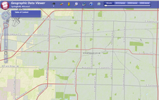
- First, hover over the table of contents in the top left corner. A menu containing all of the layers will appear. The layers are nested into categories. Click the plus to see which layers are included. Zoom in and out using your mouse or the navigational menu on the left of the screen.
- Then from the menu at the top click the binoculars icon. This is where you'll find the search tools.
- You'll notice a slider in the top menu. By default this slider is set at streets view. Move the slider over to get a bird's-eye view from 2012, 2009, and 2008. These views will be updated in 2014 and again in 2016. (That means that these photos are quite likely newer than what's available via Google.)
This brief how-to will get you started with this helpful new tool, but if you get stuck, you can contact the Information Systems department for the City of Springfield at (417) 874-1209 or you can always ask a librarian.
Find this article at