 |
Volume II, No. 2, Winter 1974 |
OZARK CAVES II
THE GEOLOGICAL STORY
Nowhere on earth can we realize the awesome age of our land better than in the exposed depths of the caves. It is as if the earth is giving us a brief view of its ancient beginnings by allowing us to trespass briefly into her being. The profound quiet seems to indicate a dead atmosphere. But most caves are alive, building and tearing down one drop of water at a time, slowly, endlessly and forever. The caves hold the secrets of the region's origins for those who can read the signs displayed in the rugged country, the potted surface and honeycombed underworld.
They contain the reasons for the high water table and plentiful springs. Reading the knowledge the caves reveal in their black depths can give us a better understanding of this Ozark land which has sustained the generations before us, is now our home and will determine our future.
About four hundred million years ago, the Ozarks region was the floor of a warm, shallow sea. The sea was abundant in hard-shelled marine animals known as brachiopods. The brachiopods lived their life span in these waters and when they died, their shells floated down and left deposits on the ocean floor. The shells, made up of calcium carbonate, were compacted by the enormous pressures of the water into hard rock layers. The continuing life cycle of these animals over the ages left very large deposits of calcium carbonate, or as it is commonly known, limestone.
The pulsating earth uplifted the entire area above the warn waters of the sea and dropped it back under the ocean several times. Each era formed stratas of rock. Geologists estimate that the last time the Ozarks dropped beneath the waters of the ocean was approximately fifty million years ago. The land brought to the surface was basically a plateau roughly two hundred miles square with elevations from 1000 to 1700 feet. Geologists call it the Ozark peneplane.
The Ozarks are surrounded by lowland plains on all sides. The area in the beginning was a broad asymmetric arch. The eastern and southeastern slopes are steep with the north and western flanks gently sloping into the western plains. Then the abundant rainfall and the rivers began to erode the plateau into deep valleys and hills with as much as 700 feet difference in relief. Most of the hilltops in the Ozarks are relatively the same height. It is the valleys that vary in depth. This erosion by rivers left the Ozarks with a rugged topography. However, some areas of the Ozarks were more resistant to, or have not undergone as much surface erosion, thus leaving flat, rolling prairie lands like the Springfield Plateau which is formed of younger Mississippian limestone.
The bulk of the Missouri Ozarks are on the Salem Plateau formed of perhaps less water resistant Ordovician dolomite which has undergone more relief changes due to uplifting and surface erosion. This dolomite is from 1000 to 2000 feet thick.
As one drives through the Ozarks descending from the high prairie-like areas in the Salem Plateau into the river valleys, one can see along the exposed bluffs or highway excavations the different strata of the Ordovician dolomite rock from the more recent Jefferson City strata down through Roubidoux, Gasconade, Eminence and Potosi formations, to the basic granite which is exposed in a few places like the shut-ins and Elephant Rocks State Park of the east central Missouri Ozarks and the Boston Mountain Range of the Ozarks in Arkansas. It took millions of years for this geological cycle to form the Ozark hills, perhaps the oldest geological formation of any size in the United States.
Caves develop in limestone or dolomite and most of the rocks in Missouri are limestone related. The Pennsylvanian limestones of northern and western Missouri are too thin to support any substantial development of cavern systems. But the thicker Mississippian limestone of the Springfield Plateau of southwestern Missouri and northeastern Arkansas and the Ordovician dolomite of central and eastern Missouri constitute an ideal environment for the developing caverns. This is evidenced by the more than 2500 known caves in the Missouri Ozarks alone.
Surface water drainage is also a key factor in the development of caves. The entire Ozarks regions tends to be a dome with the water drainage spiraling from the top around to the base. A drainage map of the area shows the flow of rivers from the east-west divide which runs roughly through Webster, Wright and Texas Counties of Missouri. The river flow is generally in three direction from this general area: north (Niangua and Gasconade Rivers), south (Current, James and Eleven Point Rivers), or east (Jack's Fork and Meramec Rivers). Of course, the drainage depends largely on the slope of the surface, the stage of erosion the land happens to be in and the small areas of weak outcropping rock.
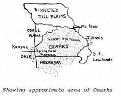
Showing approximate area of Ozarks
Caves are formed when the surface water, rivers or rain, seeps through the initial layer of topsoil and mixes with carbon dioxide and carbonic acid formed from plant growth. This produces a chemical change in the water and it becomes somewhat like a mild acid. Some of this water is taken up by plants, but, if the source of water continues, such as a rainy season, the acidulated water will begin to seep into cracks in the limestone.
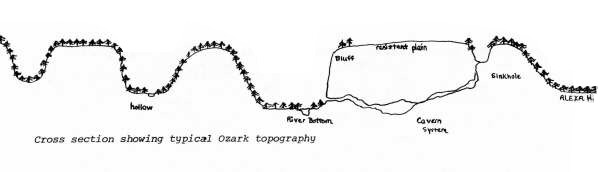
Cross section showing typical Ozark topography
Slowly, the acidulated water dissolves the limestone, enlarging the crack in the strata and at the same time dissolving a path downward. It will continue dissolving its downward path through less resistant rock until it meets some resistance, for example, a layer of rock with a certain content of chert or sandstone. This cherty limestone is more resistant to erosion than the layer above it and the acidulated water cannot dissolve it. Therefore, the water then begins to spread horizonally dissolving passageways in the rock. This is how some cavern systems can join with others to form a larger system perhaps on different stratas of rock.
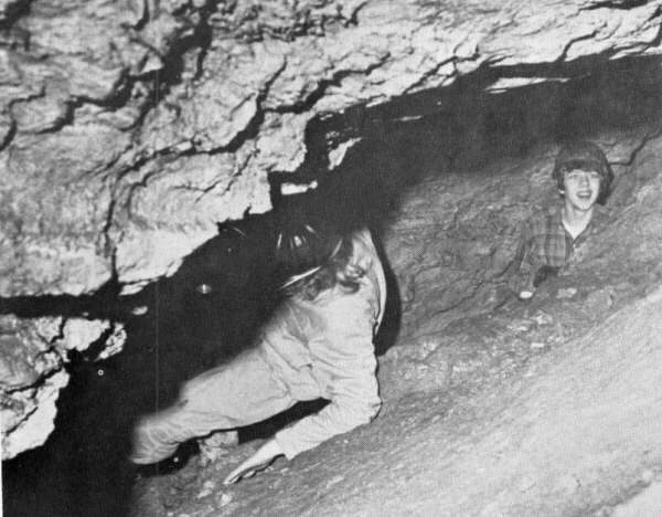
The acidulated water continues to enlarge the passageway. This is how many of the caves we visited got their entrances. The acidulated water spreads horizonally and runs out a bluff where a river has cut a deep valley into the countryside, forming an opening. Some of these openings are too small to crawl through, others eighty feet high.
The development of caves in height, depth and length depends upon the resistance of the limestone or dolomite, the eroding strength of the acidulated water, the thickness of the formations and the joint-bedding plane development.
Caves are constantly growing whether due to water erosion or earth movements.
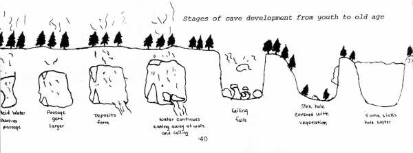
Stages of cave development from youth to old age
[40]
Sometimes a cave can open up to a new system of caverns by a movement of the earth's crust such as an earthquake or tremor. There was a bit of cavern activity during the period of the Alaskan earthquake. One cave that we visited had opened up to a new branch of caverns during this period. When we were there, this system had just recently been explored for the first time and we could still see the footprints of the first explorers.
An important factor often overlooked is the relationship of forests of the Ozarks to its geology. The solution and dissolving of the rock to form springs and caves due to the water becoming acid, is greatly enhanced by the presence of a forest cover which actually helps increase the flow of streams in the Ozarks. The forest cover slows down run-off from rainfall better than a grassland covering can by allowing more water to soak into the thin soil. The leaf litter carpeting the ground increases the acidity of the dissolving water passing through the rock.
CAVE DEPOSITS
Most caves have water dripping from the ceiling. This water is surface water which has seeped through the topsoil and through the rock into the caves, still eroding and changing the features inside. Caves with the water dripping or running in the form of a stream are referred to as live caves. Caves with absence of water are dry or dead caves.
After many thousands of years, after the water in the cave has formed rooms and passages and has found its way to the outside, the water level recedes. But water continues to come in through the cracks and through the openings. It still drips from the walls and the ceilings. The water moves through rock, becoming concentrated in calcium carbonate. When the water makes contact with the cave environment, there is a change in the pressure. There is a release of the pressure as the water comes into contact with the air. Carbon dioxide is then given off, and some calcium carbonate is precipitated onto the ceiling as the droplet of water slows, collects weight, then drops on to the floor area. The rest of the carbonate is deposited on the floor or moves on through the cave by way of a stream.
The dripping water forms many interesting, beautiful and fascinating deposits called dripstones inside caves. Ail cave deposits are made out of material from the four main sedimentary formations: dolomites, limestones, sandstones and shales. Some temporary deposits are also made out of clay or mud. The more common dripstones are stalactites, stalagmites and columns.
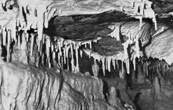
Stalactites form from water dripping slowly from the ceiling.
[41]
Stalactites are formations coming down from the ceiling. A calcite curtain may form from the dripping of water from the ceiling of a cave where a crack has been. The simplest type of stalactites are the soda straws which are straw-like formations hanging from the ceiling. Soda straws may develop if the water drips very slowly. The calcium carbonate is on the outside of the droplet of water giving the hollow soda straw condition. The hole is the size of a drop of water.
Another common drip stone in a cave is draperies. Draperies are shaped much like the draperies of a house, but not with such regularity nor with such rounded and smooth corners. Some draperies start from the wing-like expansion of icicle-shaped stalactites. Starting on the wall of a cave they drip down the sides forming a sort of blade. This then builds sort of a vertical ridge with the width the highest at the top. During the whole process the thickness of the blade stays the same. By shining a light through the drape you can see the growing procedure it has gone through. You can see the metals, iron or magnesium oxides, that the water has carried down the side of what used to be an icicle-shaped stalactite to form a very common and very beautiful drip stone. These deposits even have a ghost-like appearance.
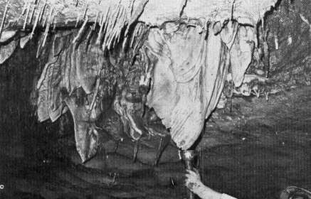
Shining a light on draperies reveals some mineral deposits that look like bacon rinds.
Stalagmites are an upbuilding from the floor of the caves. They are formed from the excess drip of the water off of a stalactite. The extra water runs off the stalactites and hits the cave floor, building up a sort of mound from which in the future a stalagmite will form.
A good way to remember which is which is that the word stalagmite means that it might join the stalactites. The word stalactite means that it is joined tight to the roof of the cave. Another way you can remember the difference is in the spelling. The G in stalagmite means ground and the C in stalactite means ceiling. Or a humorous saying may help. "When the mites come up, the tights go down."
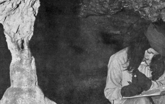
A stalactite and stalagmite often join after many years of the constant dripping of the stalactite. When they join, they form a column. Columns often grow to be enormous, sometimes as wide as they are high.

One of the most delicate and most fragile of the secondary calcium carbonate deposits are the helictites which range from the thick, the size of a pencil, to the very frail and thin, the size of pencil lead. Helictites lower from the ceiling and are crooked in every direction. They are not true drip-stones, because a helictite in its development has a slightly different method of depositing the calcite than does the soda straw or stalactite. There is not enough water moving along it to form the usual heavy droplet of water that is seen on the end of a soda straw. For this reason helictites do not have to contend with the' weight situation of the water droplet. Rather, the crystal structure controls the development of the helictite and it may go up, down, around and into, or whatever direction the crystal patterns demand, until there is sufficient weight of the water to cause it to form a droplet of water. Then a helictite may become a stalactite and go down.
[42]
Rimstone dams can form from any irregular surface. Water builds up on these irregular surfaces such as the rugged edges of stalagmites, stalictites, drapes or even sediments of mud or gravel or irregular surfaces on the rock floor. The calcium carbonate solution in the water builds on these deposits causing a dam. Then whenever the water flows over the edge, it forms a ripple or a rim creating a stone dam.
As water slowly trickles down cave walls or floors, it builds another kind of deposit, a ripply stone surface known as flowstone. Flowstone starts as a thin coating on the wall and floor of a cave, but when layer after layer is added, it looks like a waterfall that is frozen solid. It may cover mud on the floor, which is then eroded away causing the flowstone to become a free hanging shelf.
In shallow pools the calcite may fasten itself to very tiny single pieces of sand. As water slowly drips into pools, the grains turn round and round. New layers of lime are added and the sand grains become cave pearls. The pearls grow until they are too heavy to be turned in the puddle. The scientific name of a cave pearl is oolite. If you were to cut into one, it would look like a tree cut in half with many layers of lime through it.
As beautiful as the cave pearls are the anthodites, thin needles of stone that cluster on cave ceilings. These fragile white spikes are not often found in Missouri, but if found, you are encouraged not to touch them, for anthodites grow only one inch every several thousand years.
Sometimes water traveling down through the cave dissolves and leaves behind other substances beside limestone. In many caves there are curving stone feathers and flowers that look like tiger lilies and roses. These cave flowers are made of gypsum, a white mineral that is softer than limestone.
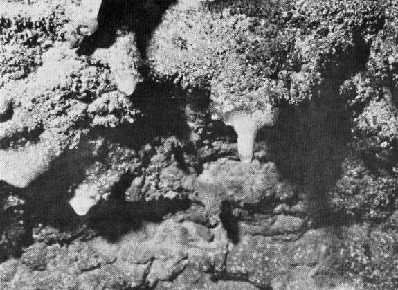
Drops of water flow through the inside of the soda straw and out the hole the same size as the drop.

Above: Water falling from soda straws form interesting stalagmite deposits on floor. Below: Janet Florence takes notes beside a column, a stalactite and stalagmite which have joined
SINKHOLES
Water erosion is the very main factor in the building and also in the destruction of a cave. The cycle of erosion is divided into three main stages--youth, maturity and old age.
The first stage, youth, is the birth of the cave. The limestone in the earth soaks up the water which then eats its way through the limestone, forming passage ways which go off in many different directions. The water usually after making a passage, exits and grinds itself out of the side of a hill or pushes itself out of the ground in a spring.
The second stage is when the cave makes its deposits. The calcium carbonate gets into the humidity of the cave and gathers on the ceilings. Deposits such as stalactites, helictites, stalagmites and draperies start to form from the dripping of the water. A mature cave is when they are formed in their proper proportions.
The third and final stage is old age. This is when the stream in the cave takes its tole. All through these three stages the cave deposits have been building up. But the water in the stream has been also tearing down the limestone walls and ceiling. When this happens sometimes the roof of the cave falls in, making a sinkhole.
The Ozark peneplane is full of sinkholes. A region that has many sinkholes is known to geologists as karst topography. In our immediate area we can go a mile in any direction and find a sinkhole or shallow depression.
A sinkhole is a surface land form, not a true cave. Most sinkholes, although, have a cave attached to them at some point somewhere. Sinkholes are mostly found in undissected parts of limestone regions, although many square miles of this limestone region are completely without sinks. Many of the sinks found are several hundred feet across and fifty to a hundred feet deep. There is a swallow sink in Lebanon which is about one mile across as well as a deeper sink where the Osage Indians used to hold council meetings.
These sinks gave early settlers of Missouri the first indication of the presence of important minerals such as lead and iron. Today they are often used for dumping places to put old junk cars or anything to dispose of.
The sinks form an important factor in the drainage of the area. Surface water runs into these sinks like drains in the street. Very few sinks hold water, so the surface water drains into them and flows directly underground to enter the underground water tables or join other waterways in caves and crevices to form springs.
Many times people fill up or build over sinks or use them as dumps. If they are filled up or built over the plug is put on a source for underground water, causing the surface water which would have gone underground, to run off into rivers. Stopping up enough of the sinks as in residential areas of cities can cause major surface drainage problems and deplete the underground sources.
Filling sinks with junk and trash, dead animals or sewage causes another problem. Surface water continues to drain in these dumps. As the water seeps through the insecticides, cans, rusted iron and other chemical and noxious agents, it carries the dissolvable waste into the springs and underground sources.
The limestone dissolves so readily that water traveling through its passageways goes rather rapidly. Therefore, the filtering action that occurs in most subterranean water systems is not very effective in a karst condition. Rather than filtering out the impurities as was formerly thought, the relatively unobstructed streams flow rapidly carrying the pollution with it. The cave water in the absence of sunlight will tend to carry some bacteria that might in a surface stream be killed by exposure to sunlight.

This is a sinkhole filled with water.
[44]
The crystal clear water trickling or gushing now out the Ozarks caves and springs is not any longer the safest water to drink. In some of the tight places we explored in caves we noticed a slight sewer smell even though we were fifteen to twenty miles from a city.
The depths of the caves tell us more than what happened here twenty million years ago. They tell us what is happening now and what will happen in the future.
Just think through what has been written in this story. The rains come pouring down. The water goes into the cracks of the karst topography into the earth to form a cave. The waters dissolve so much limestone the roof falls in. People like you and me throw dead animals, oil cans and pesticides into these sinks. The water carries the pollution from this junk and trash through springs to the rivers and the lakes. Water containing the pollution continues to run through the ground to the underground water system. The geological structure of our land which originally provided us with good water and beautiful scenery can by our not reading the signs allow us to spoil everything.
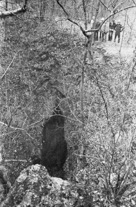
George Kastler shows staff members a more interesting sinkhole.
[We are heavily indebted to George A. Kastler, Naturalist at Bennett Spring State Park for this story. Appreciation also goes to Empire Gas Corporation for furnishing a plane for aerial photos.]
[45]
Copyright © 1981 BITTERSWEET, INC.
Next Article | Table of Contents | Other Issues
