 |
Volume X, No. 2, Winter 1982 |
THEY WENT WHERE ONLY INDIANS
HAD BEEN
SURVEYING THE MISSOURI-ARKANSAS TERRITORY
by Deidra Morgan
Photography by James Heck, Lisa Goss, Cherie Burns and Deidra Morgan
Illustrations by James Heck and Deidra Morgan
It was an early November day in 1815, when the drizzle that had been holding the surveyors up for four days turned to a steady downpour. Although it was raining steadily, the surveyors would have to go on, for they had a deadline to meet. Prospect K. Robbins, the surveyor of the Fifth Principal Meridian in the Missouri-Arkansas territory, told his men that they would have to continue the best they could. Although it was raining, they could still see enough to survey. Sometimes seeing very far was hard in the wild lowlands where they were surveying in east-central Arkansas. The land that Robbins had to cross was all swamp land covered with cane, sweet gum, cottonwood and other lowland plants. They had to face the wild animals, wade through vast areas of swamps and now contend with the weather which had turned bad, further inundating the land.
Robbins' party was to meet another surveying party headed by Joseph C. Brown, the surveyor of the base line in the territory. They were to meet him sometime around the first of November, but with the weather they were now facing, they would probably meet him around the middle of November instead.
Brown's party, also having problems covering the ground, did not know what kind of time Robbins was making. They themselves were about five days behind, for the terrain was more difficult than they had expected. Right in the line of survey they had run across still another almost impenetrable forest section on slightly higher ground. They had to run their line through it, but the forward progress was slow. The men with the axes were having trouble cutting a path. Wet and cold, the flagman started out to sink almost to his hips into a hidden hole. Fearful of an injury out in the territory miles from any help, Brown decided to proceed very slowly, even though he was already behind schedule.
Brown had a shorter distance to go, but not being aware of it, he passed what was to be the intersection on November 2 and kept on two more days before returning to look for Robbin's party. Robbins reached the base line on November 10, set a post for the initial point and marked two gums as witness trees. The initial point was the point from which all surveys north, south, east and west in Missouri, Arkansas, Iowa, Minnesota and parts of North and South Dakota were taken.
Both parties had begun from points on the Mississippi River in present day east-central Arkansas. Robbins' party began at the mouth of the Arkansas River on October 27, 1815, and headed north on the Fifth Principal Meridian to intersect the base line, which Joseph C. Brown was running. Though Brown started the same day as Robbins did to survey the base line, he surveyed west from the mouth of the St. Francis River, some seventy-five miles north.
[47]
The two parties camped near this point for a while before Robbins' party continued north, on November 16, reaching the Missouri River on December 28, a distance of 317 miles, 35 chains and 76 links. That was as far as Robbins went. Later surveyors extended the line on north. Brown departed to continue west on November 25, reaching the Arkansas River on December 5.
Though this description of weather conditions is dramatized, all the facts in the surveys of these two parties is based on historical information. The work of Robbins and Brown was necessary so that the huge expanse of land the United States had recently acquired in the Louisiana Purchase could be opened to American settlement. There was great pressure to survey the lands to satisfy military bounty requirements. Thousands of acres of land were needed for warrants given veterans from the Creek Indian wars and the War of 1812.Soldiers were given land instead of pay.
The two lines run by these men, and the subsequent township and range lines surveyed from these lines, subdivided many hundreds of thousands acres of land. The initial point where the two lines intersected in Arkansas was located 55 miles, 60 chains and 50 links north of the Arkansas River and 26 miles, 20 chains west of the mouth of the St. Francis River. It is the point where present day Lee, Phillips and Monroe Counties join. (A chain was a measuring device surveyors used until about 1900 when the steel tape replaced it. A chain, composed of 100 links each 7.9 inches, is 66 feet long.)
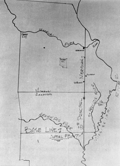
This map shows the territory that Robbins and Brown had to run. Robbins surveyed north on the 5th Principle Meridian and Brown surveyed West on the Base Line.
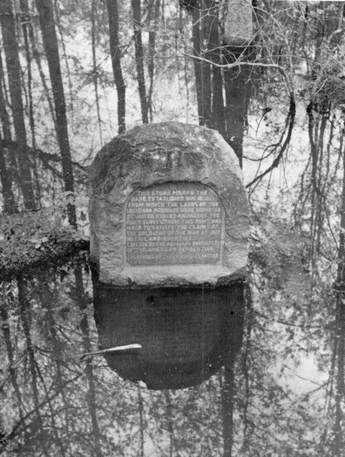
This stone marks the base established November 10, 1815, from which the lands of the Louisiana Purchase were surveyed by United States Engineers. The first survey from this point was made to satisfy the claims of the soldiers of the War of 1812 with land bounties. (Photo courtesy of Robert Elgin.)
[48]
Robbins and Brown going as quickly as they could in a straight line probably ran seven or eight miles a day. They marked every half mile corner at 40 chains and mile corner at 80 chains by setting stones or wooden posts and marking witness trees.
In the 1820s and into the 1850s, later surveyors crisscrossed the whole region, dividing it first into townships and then further dividing the townships into sections. By 1850 all of Missouri and northern Arkansas were subdivided.
Township lines ran east and west from the Fifth Principal Meridian surveyed by Robbins, and range lines ran north and south from the base line established by Brown. These lines, running every six miles formed townships which were approximately six square miles. One-half and one mile corners were set completely around each township. From the mile points, section lines were run east and west and north and south, cutting the township into thirty-six approximately one mile square sections of 640 acres each.
The surveyors who accomplished this mammoth task were contract surveyors following laws set by Congress and the orders of the Surveyor General. It was the Ordinance of May 20, 1785, which stated that the land was to be subdivided into townships and sections. There were laws establishing the personnel, their duties, the manner of surveying and how the land was to be sold or disposed of.
The surveys in Missouri and Arkansas were made under the direction of the General Land Office. The surveyor generals of various states were appointed by the President. They then appointed the deputy surveyors, clerks, draftsmen and other workers. These men, who actually did the work in the field were hired on contract.
The wages of the head surveyor in the field, who had the title of Deputy Land Surveyor, were set by the President of the United States with the provision that the entire expense of the surveying did not exceed $3.00 per mile for every mile that was actually surveyed. The average pay for a surveyor was about $2.00 a mile for running townships and section lines. This amount included the wages of his helpers, chain carriers, markers, cooks and all other expenses.
The surveyor had a great responsibility and many duties. Besides running the lines, he was obliged to keep records of all sorts of information about the land they went through. He had to note all creeks, settlements, roads, mill sites, any show of iron or any sort of mineral. He noted all salt springs and licks, mountains, drainages and any remarkable and permanent land marks as well as the quality of the land.
The surveyor kept these records, in a small handbook he carried with him while surveying. Following is a sample taken from one of these books. "A post oak 6 inches in diameter bears north 22° west, 88 links, and a post oak 10 inches in diameter bears north 11° east, 82 links." It also reads, "At 25.23 chains, we hit a black jack 5 inches in diameter. At 27.96 chains we hit a post oak 3 inches in diameter. At 40 chains we set a post for the one-quarter section corner from which a post oak 9 inches in diameter bears north 50° west, 39 links and a post oak 9 inches in diameter bears south 60° west, 357 links."
The surveyor also described the land. "Land rolling, barren, very stony soil, third rate, unfit for cultivation. Timber young growth of black jack, post oak and hickory, but scattered. Undergrowth the same. At 71.65 chains we hit a branch (creek) 10 links wide that runs west."
After noting all this information about the land, he recorded his work. "At 80 chains we set the corner of sections 25, 26, 35, 36, Township 39 North range 6 west, fifth principal. Set being a sandstone 20 inches long, 13 inches wide, 5 inches thick and 8 inches in the ground. Edges facing north and south of which a black jack 4 inches in diameter bears north 17° east, 120 links and marked with section 25 and a post oak 5 inches in diameter bears north 29° west, 74 links and a post oak 10 inches in diameter bears south 36° west, 364 links." The records were thorough and detailed.
The notes and plats were very important to the actual surveying and for later settlers. In many cases the surveyors were the first white men there.
[49]
Since surveyors were required by law to record every measurement and every little detail about the land, they carried these little pocket books called field books. They came in different sizes and shapes, but most were small enough to fit into a pocket. (Robert Elgin)
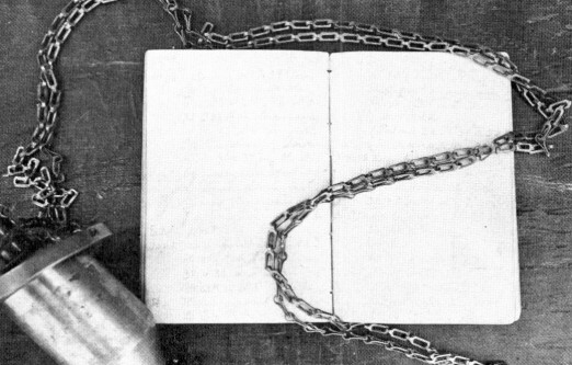
This field book, dated May 4, 1860, is one that is from the collection of Dave Krehbiel. The plumb bob, by Gurley, has a wick and oil chamber so that it could be used in nighttime work or in a mine.
Besides having to note the precise length of every line that was run, including all the offsets they might have had, they had to record the kind and size of all tress on the course that they were following. They recorded the kinds of earth or stone materials that they came across, and all landmarks they saw.
They had to tell whether the land was level, rolling, broken or hilly, whether the soil was first, second, or third rate, whether the bottom lands were wet or dry, and if subject to flooding, whether there were any springs, and if they were fresh, saline, or mineral and the sizes of all ponds and lakes, and whether they were pure or stagnant.
They also had to record any improvements they came across. These were such things as fields, cabins, houses, Indian villages or other signs of habitation such as roads and trails and their directions.
The surveyors recorded all streams, any rapids, cataracts, cascades, or waterfalls and the height of their fall in feet, any caves, sink holes, cliffs and ravines. They noted any evidence of minerals such as iron and lead and stone quarries and the kind of rock they were.
All these notes had to be written down on the spot, for nothing was to be left to memory or the imagination.
Though most of the land they surveyed was uninhabited, they did run across some previous settlement. There were claim jumpers or squatters who preceded the surveyors, and since the land had been owned previously by the Spanish and French governments, the surveyors encountered several land grants which were already in existence.
Written on one survey plat are the words, "Survey 3120 to Pascal Cerre." This early settler was given a grant of 3,000 arpents, a French measurement of about.85 an acre. 3000 arpents equals about 2,550 acres.
This grant was surveyed out at an earlier date on the lines of the section lines and township section lines. All of the old grants were eventually tied into the township section lines.
DIVIDING THE TOWNSHIPS
Townships bordered on the north and south by township lines and on the east and west by range lines were then divided into thirty-six sections.
[50]
The numbering of the sections began with section one which was always in the northeast corner of the township. The numbering continued west to section 6, dropped down one tier of sections for number 7 and continued east. The other sections were numbered using this same back and forth snake-like manner.
There was a standard method of subdividing townships into sections. The surveyors began at the southeast corner of the township on the corner of section 36. They first ran a blank line north along the east line of section 36 to get the direction of the range line and the compass variation at which the section lines would be run. That line was known, already surveyed meridian line. Then they returned to the southeast corner of the township and went along the township line to the south corner of sections 35 and 36 (which was already set) to start the survey.
They ran north 40 chains (1/2 mile), set a marker, marked witness trees and then continued north another 40 chains (1/2 mile) 80 chains in all, and set a corner. This would be the northwest corner of section 36. Then they ran a random line eastward to hit the range line and tied into the corner of section 25 and 36 which had already been set. They knew there was a corner there, but didn't know the exact direction to run to hit it. The random line might have missed the true corner a few links or maybe a chain (66 feet) or more. They would then change their compass variation to the true line and run west from the east corner of section 25 and 36, marking the true line and setting the quarter corner between section 25 and 36 at the mid point.
This completed the surveying of section 36. They would go back to the northwest corner of section 36 and 25 and run north on the true line, setting a half mile stone, and then survey section 25 in the same manner. They continued surveying each section in this way up the eastern range of sections to the south corner of sections 1 and 2. They then ran north until they intersected the township line, set the north corner of section 1 and 2 and noted their falling from the nearest section corner on the township line.

This map shows a land grant to Pascal Cerre of 3000 arpents or 2,550 acres. An arpent is a French measurement of about .85 an acre. This grant was surveyed out before the township and section lines were run. (Robert Elgin)
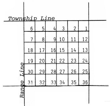
Township lines ran east and west and range lines ran north and south. Section lines were run east and west and north and south, cutting the township up into 36 sections.
[51]
Then they would come back to the south township line on the south corner of sections 35 and 34 and repeat the process on that north-south range of sections.
They would go through the township until they got to the westernmost range of sections at the south corner of sections 31 and 32. From here they would continue as before by surveying section 32, but instead of going on north to section 29, they would run west on a true line until they intersected the range line on the west side of the township and set the west corner of sections 30 and 31. They would note their falling with the already set corner of section 36 and 25 of the next range to the west. In this way they surveyed two tiers of sections on the last northern advance in the township.
After all the surveying was completed down to the sections, the land was ready for settlement. However, not every section in a township could be acquired by the public. Under Ordinance of 1785, section 16 of every township was to be set aside for a school. Approximately 80 million acres of public land was set aside for public education. This was one of the most remarkable laws of surveying.
Although they could not legally get title to the land, people started moving west of the Mississippi about 1800. This meant, of course, that there were squatters.
Most of the land in the early years in Missouri and Arkansas was patented. In other words, it was purchased from the government at about $1.25 per acre. The homestead act did not come into effect until about 1862. This act allowed a setter to prove up land by occupying it and by living on it. The setter would pay a certain amount of fees for office work and maybe surveying. Then he acquired the title to it.
LIFE OF A SURVEYOR
There were several men who affected the outcome of the Missouri surveys. Prospect K. Robbins and Joseph C. Brown ran the Fifth Principal Meridian and base line. Daniel Dunklin was in charge of all Missouri and Arkansas surveys in 1823 or 1824. Other persons who had a hand in the Missouri-Arkansas surveys were William Rector, the first Surveyor General of Missouri and Arkansas, whose office was located in St. Louis, and in Missouri, William Ashley (1778-1838), an explorer and fur trader, who later became a Missouri congressman from 1831-1837.
All these surveyors were men skilled in surveying. Although some colleges at the time of the Missouri surveys had courses on surveying, such as William and Mary College in Virginia, from which George Washington graduated, most surveyors learned by being apprentices to other more experienced surveyors. Even today, although there are many courses taught on surveying, a great deal of the training comes from working in the field.

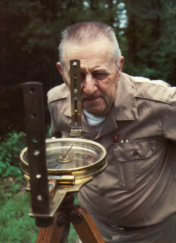
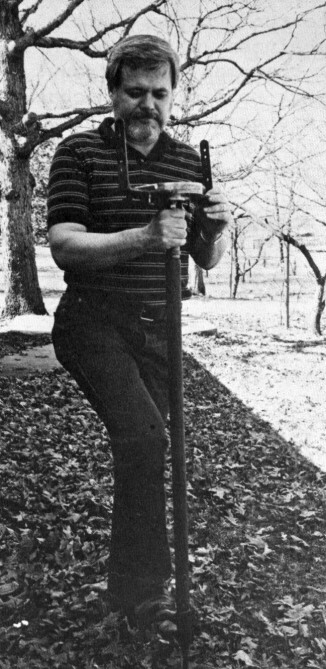
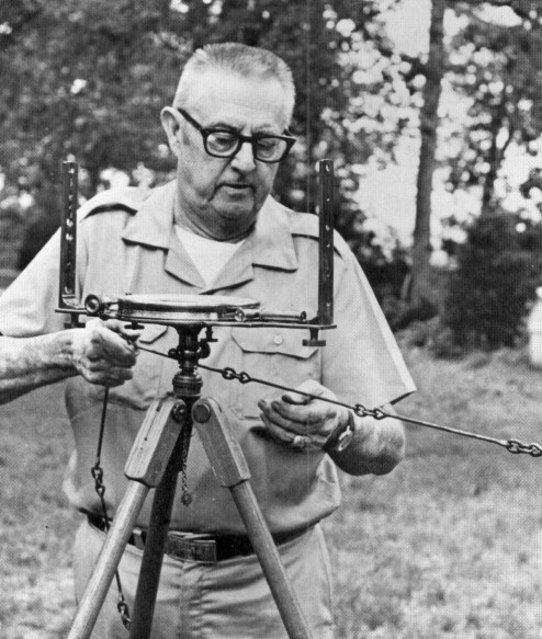
Robert Elgin, surveyor and engineer for R. L. Elgin & Associates, is shown here holding a leveling rod. This picture was taken on September 5, 1934, when he first started surveying. (Photo courtesy of Robert Elgin.)
[52]
The life of the early surveyors was a very hard one, for they had to face all kinds of dangers and were exposed to heat and cold, dry conditions and to diseases and accidents in an unpopulated area. They had to travel across land where there were no roads, only an occasional Indian trail. They had no cabin to come home to, only a tent in which they lived with their fellow workers.
They had to carry all their supplies with them. For a party of six for approximately four months, they would need about 8 barrels of flour, 3 barrels of clear salt pork, 3 or 4 bushels of white beans, 10 pounds of tea, 60 pounds of coffee, 150 pounds of good dry sugar, 2 bushels of dried apples, pepper and salt, 25 pounds of rice, 25 pounds of oatmeal, 5 pounds of castile soap, and any other articles the head surveyor thought he could afford, for he had to pay for all supplies from his salary.
The life style was a very primitive one. Their shelter was a large soldier's tent. Their covers were mackinaw blankets. They carried their water from the nearest creek in a tin pail and washed in a small basin. Other utensils were knives, forks, spoons, frying pans, matches and other little necessities. What they brought along depended on the country they were surveying.
To carry the supplies they used one or two pack mules, packsaddles, and a quantity of good bags for packing provisions. They obviously had to carry everything with them.
They used very simple equipment so they would have a lighter load to carry. The surveying equipment they needed was a compass or a transit, tripod or jacob staff, a flag of some sort, range pole, chain and chaining pins.
Sometimes the surveyors took along an extra compass in case the main one got broken since they were pretty easy to break. The main thing that might be injured was the pivot that the needle turned on. When the pivot got dull the needle swung very slowly and might not return to the same point all the time. For that possibility they had an extra pivot or some sharpening stone to sharpen the pivot. Although compasses did tend to break, they did not break as easily as transits.
For their records they needed some kind of drafting supplies for drawing up their plats, which were drawn to some extent in the field, a notebook and a pen or pencil. A pencil was preferred as it was easier to handle than a pen and a bottle of ink. They also needed scribing knives, for marking trees, axes and hatchets for clearing lines, shovels for digging holes to set posts and stones, and, of course, camp equipment. The camp equipment would probably include a tent, some sort of ground cloth, blankets or buffalo robes.
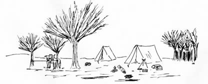
The early surveyors had to carry all their supplies right along with them. Their home was large soldier's tent and their kitchen was a campfire. They got water from a nearby creek. They used simple equipment so they would have a lighter load.
[53]
When they moved into a township, for instance, if they were going to subdivide a single or several townships, they would move into a central location and set up camp. The cook would stay in camp while the survey group would start working out of that camp, coming back to it every night. As they got further and further away, the camp would move right with them. Robbins, while running the Fifth Principal, running six, seven and eight miles a day, probably had his pack train travel right with him. The men would hardly live off the country at that time, for there were not enough settlers. Some of the older records indicated that the surveyors lived mostly on salt pork, beans, coffee and wild life, such as deer, as they would kill it. They probably had a pretty rugged existence.
On an average day surveyors might run from four to eight miles, depending on the type of land. Some might have gotten ten. Robert Elgin, engineer and surveyor for R.L. Elgin & Associates in Rolla, Missouri explained the procedure. "They had to go north forty chains and set a corner and take at least two witness trees. That takes a little while. Then they had to continue north another forty chains, set a corner, take two or four witness trees, then turn east and run a random line and at forty chains set a temporary post. Then they would run on into the next corner, find out how much they had falling off of it and figure how much they had to move this temporary post to get it at the mid-point. Then when they got that calculation, they would probably take two witness trees to it and go on. That is probably what they did without actually running the line back. Some have run it back and blazed it. But that takes quite a little time.
"Today on a corner search if we can run two to three miles, we are doing awfully well. We're running a good deal slower because we're looking for the old markers. Sometimes if we run twenty or forty chains, we might have to make a search area that might be 150 feet in diameter. We might spend an hour just looking for a corner. But they were punching lines through the country first."
Since the surveyors had to follow straight lines regardless of the topography and measure on the level when traveling through the country, they used short chains, so the surveyor would not be tempted to stretch a chain across ravines, causing a place for error. (A short chain is 50 links or 33 feet).
Surveyors also had to blaze the trees as they went along. If they hit a tree on the line, they were supposed to put a long blaze on the face of it. If they passed trees on the right, they would blaze on the right side of the tree, if on the left, they would make a blaze on the left side of the tree.
They marked the trees near the mile and half-mile corners differently. They called these trees witness trees for they were more evidence of the location of the corner. The witness tree is a tree to which the corner is tied. As a surveyor went north, he would tie his corner to about four trees. "For example," Elgin said, referring to an old plat he had, "this surveyor set a stone for the corner. He then tied it into a black jack 4 inches in diameter which was north 17 degrees east, and he had a 5 inch post oak north 29 degrees east, and a Dost oak 10 inches in diameter south 37 degrees west, and black jack 8 inches in diameter south 45 degrees east 218 links. So with these four witness trees, if this corner marker was lost, you could come back and reset it from any one of the trees or a combination of them."
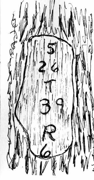
At about chest height the surveyors would rake a blaze on at least one tree in each section. On a big blaze, scribed with a marking iron, one might find the words, "Section 26, township 39, range 6." They didn't usually burn the words in it because it would be too time consuming to heat an iron to do that each half-mile.
This 1850 Gurley is a brass vernier compass. Mr. Elgin explains how the surveyor would look through the first sight and line the second sight up with the flag pole. This compass is just one of the many instruments that Mr. Elgin has.
[54]
"They used the same marking irons we use today, sort of awkward looking knives," explained Elgin. "There are several models of these, some of which will cut circles, though that is hard to do. But with these irons you can cut a pretty good cut in the tree with it. It was a wicked looking knife."
Crossing big rivers was another problem for the surveyors. Streams like the Gasconade in Missouri, really presented some problems. Therefore, many of the surveys ran into the river and stopped. Then the survey would be run in from the other side. This practice makes problems for surveyors today because the lines usually never line up, causing jogs along the river.
This practice and other inaccuracies in surveying has caused the wording in many deeds to say so many acres "more or less."
"They said this because it's awfully hard to tie down exactly, unless you use very, very precise methods. And in the old days they didn't," said Elgin. "When using the chains and compasses they had, the precision was a great deal less than it is today. Matter of fact, when they were subdividing the country, a township was supposed to close within five chains (330 feet) and individual sections with one chain (66 feet). This is quite a little difference. That is pretty rough work. So that's why they put in the stipulation 'more or less' because the accuracy or precision was not too great."
Today surveyors often have to go back and retrace most of the old lines that the surveyors ran back in the 1815s to 1850s. When retracing the steps they took in that time, modern surveyors must do quite a bit of detective work to search it out. Bob Elgin has done a lot of this type of work.
"You have to put yourself in their place," be said. "You really have to follow the footsteps of the old surveyor when you're doing retracement work. Usually we start on an old corner we know is good and then we'll start running a line. Then when we tie into an old corner, we'll adjust our variations just as they did and also their measurements, because our measurements would differ from theirs. After we've worked in an area for so long a time, we can work out a proportion between our measurement and their measurement. Then we can change our measurement so that we'll be fitting theirs. If we're over-running, why take a little off, and if we're under-running, add a little on. We adjust the measurements, to make ours coincide with the old measurements, since everybody measures a little different. And, of course, these old guys were going fast. Since they were getting two fifty to three dollars a mile, they had to punch lines through the woods in a hurry. Their precision was a little less than desired, but it wasn't bad for that day. We find when we're retracing old lines, if we're a little bit sloppy, we'll balance."
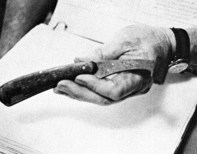
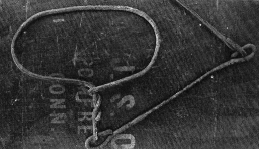
This scribing knife (above) was similar to ones used to mark witness trees such as this mark found in a cut tree (below left). The drawing shows an example of what might be scribed on the bark of a tree. The knives were very effective, allowing the workers to cut about a quarter inch deep into the tree.
 |
 |
[56]
HOW THEY SURVEYED
In the actual surveying of the Missouri-Arkansas territory, a surveyor had to have a thorough knowledge of the equipment and the methods of using the equipment.
To begin the survey, the first thing they would do was to set up their compass. Most surveyors preferred to used a tripod to set the compass on, though they could use a jacob staff. The jacob staff was harder to get to stay when they reached the rocky ground of the Ozarks because it is just a sharpened pole that is stuck in the ground. A tripod gave better stability.
With the compass ready and sighted in the correct direction, the flagman would head out along the line that they were surveying. He would go out as far as the compass man could see him. It generally depended on the ground cover and the weather how far away he could see the flag with his compass. The flagman would then wait for the compass man to signal him which direction to move the flag.
Next, the compass man would look through his sights to the flag. He would motion to the flagman to move the pole right or left. After the compass man had the flag sighted in, he would tell the front chainman to run out the chain. There were two chainmen, the front chainman and the back chainman. The front chainman would pick up his eleven chaining pins, which are used as markers and to hold the chain in place, and he would start walking toward the flagman,dragging the chain behind him. Before heading out, though, he would throw down one chaining pin as the zero pin to mark the beginning point and then he would start dragging the chain along the ground on the line. The back chainman would hold the other end, while the front chainman pulled his chain tight and laid it on the ground.
When the front chainman got to the end of the chain, the back chainman would yell "chain." The front chainman would stop and move over in line with the flag. Pulling a pin from the loop of chaining pins he carried, he stuck in a pin at the handle of the chain and yelled "stuck." The back chainman would release his end of the chain, remove the pin and put it on his loop. The front man would go ahead dragging the chain while the back man would move up to the pin just stuck and hold the end of the chain as before. The two continued this measuring, the front man putting in the pins, the back man pulling the pins as he came to them and putting them on his own loop as they progressed on.
When the front chainman would run out of pins, he would yell "out." That would mean for the back chainman to come up and give the front chainman the ten pins on his loop in exchange for the front chainman's empty loop. There were only ten pins on the loop, because the eleventh pin would still be stuck in the ground holding the chain. Using all the pins would mean they had gone ten chains or 660 feet. After the front chainman would run out of pins again, they would start all over. Surveyors use the same method of surveying today, except they use a steel tape instead of chains. However, they still call them chains.
Many times if the surveying was going across rough country, the chainman probably could not go a full chain without having to break chain. This is where they would be going across the country, and would come to a place where the compass man would have to pick up his compass and start over. By breaking the chain the surveyor's measurement might read 5 chains and 36 links, instead of 6 full chains.
[57]
The jacob staff is a wooden pole with a pointed end to stick in the ground. Most of the earlier surveyors used a jacob staff because it was easier to carry than a tripod. However, it was not used as much in the Ozarks because of the rocky ground. Jacob staffs were used mainly with cruising corn?asses, mostly in forestry work. This particular jamb staff came equipped with a foot bar to help surveyors stick it in the ground.
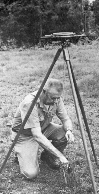
The tripod with three legs was easier to get balanced. When using a tripod, the surveyor had to use a plumb bob (below) to set it accurately over a point. The original surveyors probably didn't use a plumb bob, but estimated the position of the compass over a point. Modern surveyors do use them for greater accuracy. On some transits there is a hood beneath the transit on which to hang the plumb bob. The surveyor sets the tripod over the little stake and then he uses a plumb bob to center it by pushing the legs into the ground until the plumb bob was directly over the stake.

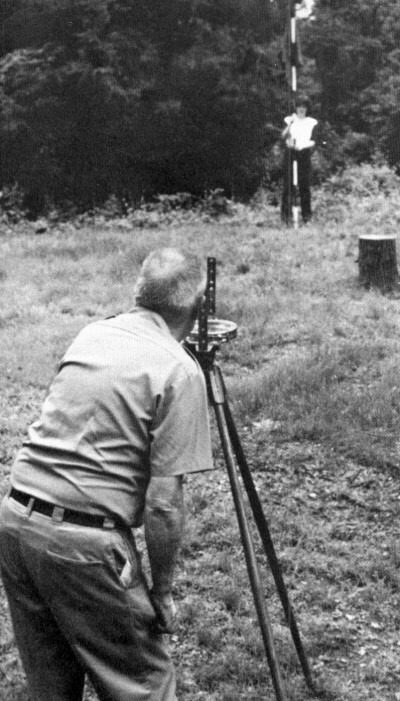
The range pole which was usually painted alternately red and white for visibility, was used to get the line run correctly. There was usually a red flag attached to the top. The compass man would look through the sights on his compass and line in the range Dole, or flag pole as it is sometimes called.
[58]
The purpose of surveying was to run accurate lines and measure the distances. The major piece of equipment for measuring was a chain. Chains, composed of links, could be folded up for ease in carrying or storing. A standard chain was 66 feet or 100 links, though most chains were 33 feet or 50 links. Surveyors used the shorter chains in rough country to avoid stretching the chain across a ravine.
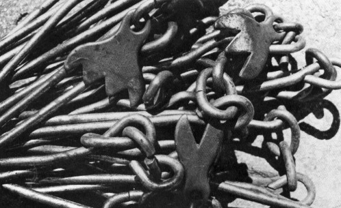
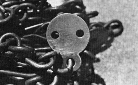
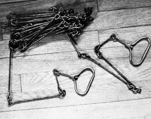
To keep track of measurements less than a chain, there were tally markers to mark off every ten links. Most markers are round with holes and some are like crow's feet. Each prong or hole on the marker indicates ten more links. Some even have numbers on them instead of prongs or holes.
Most chains were commercially made. A surveyor working in the rural area of Missouri who could not afford to buy a chain made his own. He was a good craftsman, but each link being different made a larger margin for error.
The chain was replaced by more accurate steel tapes around the turn of the century. It became impractical because every place that the links fit together there was a wearing surface. The mere they used the chain, the longer it got. They allowed for the inaccuracy by
[59]
As the surveyor proceeded along the line, he obviously had to record how many chains he had gone, for his purpose was to measure as well as mark the line. He recorded this by seeing how many complete chains he had gone by counting the pins missing from his loop. If the measurement was less than a chain, in other words, if he had to break chain, he recorded the measurements by reading the tally markers on the chain.
A tally was attached to the chain every 10 links. These tally markers came in different shapes and sizes and had different ways of indicating whether it was the first, second, third, etc. tally. Some tallies had numbers on the markers, some had holes or little prongs cut out of the markers.
Then when the front chainman reached the flagman, he would yell, "set a point," or he might just wave a hand over his head, which meant set a point. The surveyor would then set a point by pulling up his compass, moving up and setting over that point. Then they would start the whole process all over again with the flagman moving on. After they had measured a half mile, the early surveyors would usually set a stake or something to mark the half mile. Today on ordinary surveying surveyors set stakes closer than that.
When the early surveyors went through, they were required by law to set corner and half mile markers. They set some temporary ones made out of wood and some more permanent ones by using sandstone.
Some of these old corners are still in existence, while many have rotted away or disappeared. Today, surveyors go back to do corner searches, which requires some detective work, but they do find some of these old corners.
"They usually recovered about fifty-seven percent of these old corners." Mr. Elgin explained. "It takes a lot of detective work and a bit of archaeological work to do it. It's not easy, but you can do it if you're very careful and know what you're doing. We find a lot of them. There's still an original witness tree standing at what would be the southeast corner of Gasconade County. It was one of the 1816 witness trees."
Then when all the surveying job was done, the surveyors would pack up their equipment, pull up the stakes of their tents and head home. They would probably go home to their families to rest up and get ready for their next assignment.
The efforts and troubles of the early surveyors are not written up in history books nor celebrated in stories as are the hardships and trials of the early explorers and settlers and the heroic efforts of lawmen to make settlement possible. Even the exploits of very early trappers and Indian traders are better known to modern readers. But before any true settlement could occur, before anyone would get legal title to any real estate, even before anyone knew much about the natural geographic and ecological particulars of any area, the surveyor and his team of about six workers on a total budget of about two dollars a mile, quietly, efficiently and bravely crisscrossed every square mile of thousands and thousands of wilderness acres. Alone and heading into territory where only Indians had been, these skilled and kathy men, using inferior and sometimes homemade equipment, ran lines which have a direct bearing today on every plot of land, every building and road in a six state area west of the Mississippi River. It all began on that wet November day in 1815 when Prospect K. Robbins and Joseph C. Brown established the Initial Point.
[60]
Copyright © 1981 BITTERSWEET, INC.
Next Article | Table of Contents | Other Issues
