
Volume 2, Number 2 - Winter 1965
Mining Boom of the 1890's
From the St. Louis Daily Globe-Democrat
Courtesy of Edwin H. Aehle
THE OZARK UPLIFT
Ten O’Clock Run in Its Peculiar Relation to Recent Zinc Discoveries.
Special correspondence of the Globe-Democrat
FORSYTH, MO., September 18, 1899---’Ten O’Clock Run’ is one of the mystifying expressions which the newcomer encounters in the Missouri - Kansas- Arkansas zinc and lead country. ‘Eleven O’Clock Run’ is another. A pioneer will say a certain discovery is on ‘Ten O’Clock Run’, and that another new prospect is on ‘Eleven O’Clock Run’. The vernacular of the country is as distinctive as its mineralogical character and as picturesque as its scenery. Old-timers still refer to this as ‘The Country of the Six Bulls’. And when they are asked for the origin, most of them have forgotten it, if they ever heard. A hundred years ago Edmund Jennings came out from Tennessee and lived fifteen years among the Indians of ‘Aux Arcs’, as the earlier French explorers had named this region. When he went back to Tennessee he had marvelous tales to tell of the forests and caves and springs and rivers and game in what he called ‘The Country of the Six Bulls’. This, it appears, was Jennings’ way of pronouncing ‘boils’. ‘The Country of the Six Boils’ was the country where six great springs, boiling up from the enormous reservoirs of limestone formation started rivers on their courses. Indian, Shoal, Center, James, Spring and North Fork were the six ‘boils’ which inspired the name of ‘The Country of the Six Bulls’.
Jennings’ hunting and fishing stories of the Ozark country fired the minds of his Tennessee listeners, who were born with a strain of Nimrod’s blood in their veins. The tide of immigration to ‘The Country of the Six Bulls’ started almost as soon as the United States had expanded with the Louisiana Purchase. Long-legged Tennesseans poured into the Ozark country, and the Osages and Delawares were crowded out.
‘Ten O’Clock Run’ and ‘Eleven O’Clock Run’ were invented by the miners of a past generation. They came into use when the compass and the sun dial were of common use. Without being able to give the scientific explanation practical mining men, having located a good prospect, look for the continuation of it to the northwest or to the southeast of point of discovery. If the course of the mineral is on the line of shadow which the sun will throw by the dial at 10 o’clock it is a 10 o’clock run. If the mineral lies along the shadow line of an hour later by the dial, it is described as
[9]
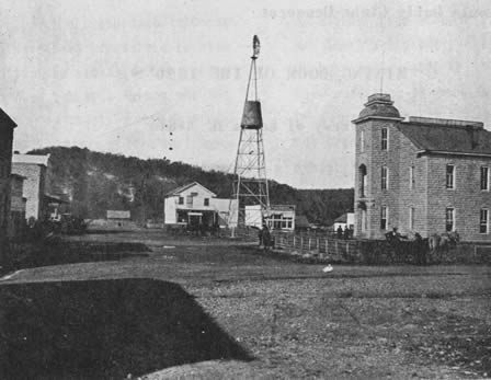
Courthouse square, Forsyth, Mo., 1899
being ‘on an 11 o’clock run’.
Handed down from the pioneers who ‘gophered’ in the Ozark country for lead forty years ago, these expressive phrases are in general use now. They are applied to the new discovery, zinc. They possess a significance far beyond that which attached to them when they were first used by the lead miners. The theory they represent is being borne out by the recent discoveries which go to establish much wider extent of the mineral fields than was formerly supposed to exist.
If anyone who is interested in the new mineral era of the Southwest will take a map, and with the Joplin and Galena district as the starting point, will project a 10 o’clock line to the southeastward, the result will astonish. It will be found that this Ten O’Clock Run from Joplin will pass through Aurora, now the scene of activity with forty drills and of discoveries only second to those of Jasper county, Mo., and Cherokee County, Kan. This Ten O’Clock Run passes through the corner of Barry County, where some late prospecting has indicated the probable existence of fine mineral. Thence the ‘run’ is through the heart of Stone, passing near the county seat of Galena, and the center of fresh interest. The southwest quarter of Taney County is traversed, and the State line is crossed at such an angle as brings the run into the very heart of the Arkansas zinc field, now attracting the interest of the mineral world. Dodd City and Lead Hill, two centers of discovery and development, are almost bisected by the straight extension of the great Ten O’Clock Run. Continued on the map the ‘run’
[10]
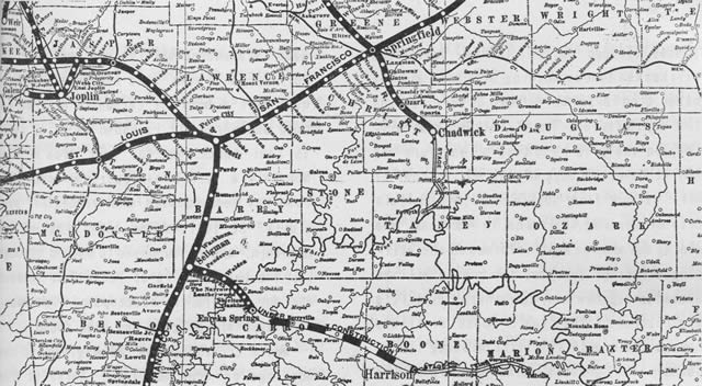
Frisco Railroad map of southwest Missouri and Northwest Arkansas, 1899.
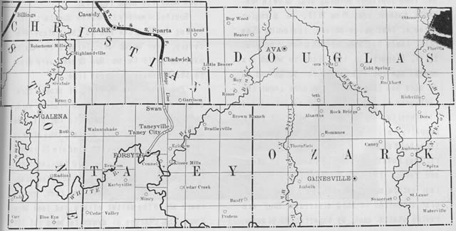
Christian, Douglas, Stone, Taney and Ozark Counties, Mo. This 1899 map carries an advertisement saying that "The St. Louis & San Francisco Railroad Company has for sale some 75,000 Acres of Land in Missouri and Arkansas at from $1.50 to $3.00 per Acre on much of which mineral has been found."
[11]
passes through Marion County, Ark., and strikes the famous Morning Star mine and the other rich digs on Buffalo River. Perhaps the way to impress Ten O’Clock Run most vividly on the mind is to take a long rule and lay it down the edge of the map so that it will extend from Joplin, Mo., to Buffalo City or Morning Star mine, in Arkansas. The mining man who has kept informed on the stirring events of the past few months will be amazed to see how many new mineral districts are located on the ‘run’. These districts make a chain with few still missing links, between the greatest zinc centers of the Ozark country.
Within ninety days Taney County has contributed some notable additions to the stock of information about Ten O’Clock Run. South of Forsyth, the county seat of Taney, about eight miles, is Pine Hill, often called Pine Mountain. It is a considerable elevation, about 600 feet above White River. Ten O’Clock Run from Joplin to Morning Star mine in Arkansas passes over Pine Hill. In a region three or four miles square, including Pine Hill, there has been opened a new zinc district. Property in the vicinity which six months ago could be bought for $2.50 and $3 an acre has jumped to $10 an acre under the influence of the diligent prospecting and its results. Joplin men who sold out their property in Jasper County for $60,000 have taken hold of some land and are investigating it. They have found enough to encourage them, and refuse to sell. Johnson & Lemon, the real estate men of Forsyth, have given especial attention to this district. They are having shafts sunk by experienced miners.
Lead is abundant all the way down from the surface, and some zinc has been found. In one shaft a body of carbonate of zinc has been uncovered. It is known to be at least 15 feet thick. On the east side of Pine Mountain a strata or fluorspar containing lead has been located and traced for over a mile. It is found on both sides of the mountain, and is supposed to extend through it. The thickness is at least 8 or 10 feet and maybe more. In outcrops of Pine Mountain silicate of zinc has been found.
Monte Cristo is the name given to the workings on Pine Mountain. Three of the shafts are within 100 feet of the highest elevation. They struck mineral within 4 fee of the surface. The first shaft passed through deep red clay, carrying lead and red carbonate of zinc. At 12 feet rock was found and in this were disseminated resin and velvet jack, zinc silicate and lead. The ore has grown richer with depth. The other shafts show much the same results.
Southeastwardly from Pine Mountain, following Ten O’Clock Run is the latest discovery, over which all Forsyth is talking excitedly. It is on Bee Creek, very close to the Missouri-Arkansas line.
‘Everybody was finding it around here, and I thought I’d try,’ Sam Francis said in explaining how he came to let off some dynamite shots in ‘duck nests’, thus blowing into sight a body of rich zinc ore 20 inches thick, and nobody knows how far- reaching. Francis found a place which looked promising. A small stream fell over a cap rock, underneath which the softer strata had been torn away. The charges of dynamite were let off
[12]
under the little waterfall, and they brought to view the jack of very high grade. Seemingly the find on Bee Creek is one of the notable developments. A single shot brought out 300 pounds of ore.
That Taney County has lead ore is no new story. When Uncle Sampson Barker, one of the oldest hunters of the White River country, wants bullets he never thinks of going to the store, even in this day of fixed ammunition at low prices. Uncle Sampson does just as he has been doing since he was a boy. He goes out in the hollow, picks up some chunks of lead ore. He selects a stump, white oak preferred. The cavity he fills with light wood. He touches a match, piles on the ore, and goes away. When the smelter has cooled off Uncle Samson goes back, rakes the lead out of the ashes and molds his bullets. There is almost no section of the country where this ‘float’ lead can not be found. With very heavy rain pieces are washed out of the clay.
In looking over the records of the United States Land Office, Mr. Johnson recently made an interesting discovery. It appears that the lead mining capitalists of Southeast Missouri made a mineral survey through Taney County thirty years ago. At that time nothing was known of zinc in the western part of the State. Joplin had hardly come into existence, except for some lead ‘gophering’. What these capitalists were after was lead land. They ran a survey across Taney County from Granby, in Missouri to Lead Hill in Arkansas, a distance of perhaps 100 miles. They prospected with shafts and satisfied themselves so well the land carried lead in remarkable quantities that they ‘cash entered’ from the government a long string of forty-acre tracts. Among the names which appear of record as purchasers of the government lead lands in Taney are Lewis V.
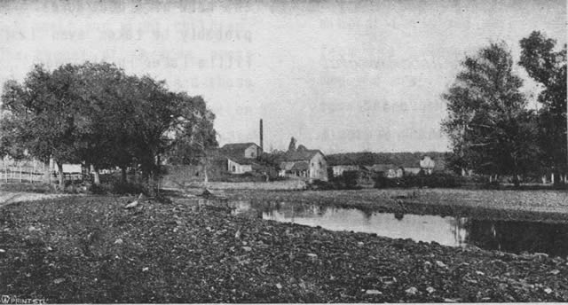
Lead Hill, Arkansas, 1899
[13]
Bogy, Amadee Valle, Henry T. Blow, Eben Richards, Edwin Harrison. Many of these entries were made in 1872. Some of the land remains in the hands of the heirs of these men. Much has been allowed to go for taxes. It is an exceedingly interesting fact that these lead entries are found to be located on the Ten O’Clock Run, along which are now being developed the new zinc districts.
In Taney County, Ten O’Clock Run, viewed by the latest prospecting, means a belt of mineral land two miles wide, blending to a width of ten miles. The richest mineral discoveries have been in the two-mile strip.
Mineral Discoveries Inspire a Run Upon Uncle Sam’s Land Office
THE RUSH TO ‘CASH ENTER’--OVER 100,000 ACRES ABSORBED- - A NEW ERA DAWNS I N SOUTH MISSOURI COUNTIES- - SQUATTING NO LONGER SAFE
Special Correspondence of the Globe-Democrat
PROTEM, MO., Sept. 19, 1899--Rapid decrease in the amount of government land in Missouri is one result of the growing interest in zinc mining. Most of this government land is in southwest Missouri. Springfield is the location of a land office which has charge of the district embracing several of the counties in which recent discoveries of zinc have been numerous. About eighteen months ago a count of the tracts still belonging to the government made by the register and receiver at Springfield, showed 306,700 acres. This land was distributed among fourteen counties. Recently the plats and the records have been examined again. It appears that the government now has on hand in these counties 200,000 acres. One-third of the land which twelve months ago was subject to homestead entry at a cost of $14 for 160 acres, or cash purchase at $1.25 per acre, has been absorbed. At the present time this land is being taken at the rate of 6,000 acres a month.
‘You would be surprised,’ said Recetvet Ramsey, at Springfield, in talking of this new demand for public lands, ‘to see the men who come here for information about the location of tracts untaken. They are men of means, and for the most part from outside of the State. They want to know what lands are to be had for cash entry, and when they have got the descriptions and locations they leave to look at the tracts. This is the dull season for land office business under ordinary conditions, but the land is going at the rate of 6,000 acres a month, and will probably be taken even faster than that a little later in the year.’
Taney is one of the counties which is feeling in a marked degree this widespread desire for land in the mineral field. Eighteen months ago the records at the land office in Springfield showed that the government still had 89,000 acres of the public domain within the limits of Taney. Now only 61,320
[14]
acres remain. And that amount is being reduced rapidly. In a single day at Forsyth, the county seat, this month, the papers were made out and forwarded to Springfield for the transfer to individuals of 1,280 acres of this government land. Last night there were in Forsyth men from six States and Canada looking for land. They represented Michigan, Wisconsin, Illinois, Iowa, Kansas, Nebraska and the Dominion.
The 28,000 acres of government land taken in a few months includes only a fraction of the transfers of Taney county property much deeded land has changed hands from the old settlers and holders to the newcomers and investors. A significant change in the character of the government entries has taken place. When the rush to Taney County set in it was made up largely of farmers from Northern and Western States, who seemed to have awakened to the opportunities presented to get homesteads for $14 and five years’ residence. Men came with their families and selected from the unoccupied lands the tracts that seemed most desirable for stock farms. One old farmer from Illinois located eight homesteads for himself and eight children, 1,280 acres. The number of Germans among these new settlers was noticeable. And those interested in placing the new population were struck by the quickness with which these thrifty people recognized the encouragement in the government lands which the natives had looked upon as of no value. Homesteading went on for several months at a rate never before known in this part of Missouri. Then came the transition over which the South Missouri counties are still marveling. Suddenly it seemed to dawn that the North Arkansas mineral field, which everybody knew came right up to the South Missouri line, might cross that arbitrary boundary. The same hills and hollows and geological conditions might mean the same, wonderful ore bodies. Prospectors and investors began to study surface conditions, and to locate desirable lands, leaving the questions of State and county lines to be considered only when their investigations reached the stage of purchase and record.
‘Sixty days ago,’ Mr. W. H. Johnson, the lawyer and real estate man of Forsyth, said, ‘I didn't have a mineral sample in my office. I doubt if there was a specimen in town. All of the talk was of homesteading. My correspondence related to ranches. The change in the demand for Taney County land seemed to come all at once. For a month I haven’t made out a homestead entry. Everything is cash entry now. People who can’t stop to fool with homesteads have come. These men want mineral lands and want to buy them outright from the government at $1.25 an acre. The men who are investing are from all parts of the Union. They have almost overcrowded us. A couple of weeks ago we induced one of our lawyers to turn his home into a hotel, the old accommodations having proven entirely inadequate. With this new hotel we often run short of room and have to quarter people among the residents of the town. We have
[15]
still 61,000 acres of government land opened to cash entry at $1.25 an acre, but it will be cut down to a much smaller aggregate by the end of the year the way this investment is going.’
Ozark County adjoins Taney County on the east. It lies in part north of Marion County, Ark. A little more than a year ago Ozark had 109,000 acres of land subject to homestead or cash purchase at $1.25 an acre. The amount has been reduced to 78,540. Prospecting is going on all over the southern, part of the county.
In Stone County, adjoining Taney on the west, and bordering on the Arkansas line, the public domain has been cut down from 26,289 acres to 18,600 acres by the recent transfers mostly to mineral hunters. Through Stone County passes the famous Ten O’Clock Run, by which the miners trace close connection between the Missouri-Kansas zinc district, and the Arkansas field already developed.
Christian county has less government land than its neighbors when this mineral interest set in. The amount has been cut down one-fourth.
Douglas is another Missouri county which has come in for attention from the mineral land buyers. Of the 13,000 acres of government land there 4,600, more than one-third,
[23]
has passed to the hands of individuals and syndicates in a few months.
W. B. S.
THE FRISCO A MINERAL LINE
The St. Louis & San Francisco Railroad penetrates the mineral belt of Southwestern Missouri and through its closely associated connections, will soon reach the heart of the Northern Arkansas district.
At this writing it is still necessary to use stage lines to some extent to reach the heart of the Northern Arkansas district, although a line of road is now under construction from Eureka Springs eastward.
During the past year a second line of stages has been put on to connect the Frisco with Taney County, Mo., and the northern tiers of the Arkansas zinc counties. These stages leave Chadwick daily, and run through to Forsyth via Taneyville. At Forsyth connection is made with first-class stage service to Lead Hill, Dodd’s City and Yellville A surprising amount of work has been done on these Arkansas roads (and) the stage journeys will be found especially attractive during the spring and summer months.
(These articles appeared in a booklet, ‘The Ozark Uplift’, by Walter B. Stevens, concerning the Zinc and Lead Mining Industries tributary to the Frisco Line, 1900.)
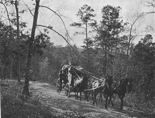
Stage Coach from Eureka Springs to Harrison, Ark.
[24]
This volume: Next Article | Table of Contents | Other Issues
Other Volumes | Keyword Search | White River Valley Quarterly Home | Local History Home
Copyright © White River Valley Historical Quarterly
