
Volume 1, Number 9 - Fall 1963
The Spotlight
The Arch on James River
by Mary Scott Hair
If you, a traveler from beyond our hills, should one day stop to ask this question of a regional member of the younger generation, "Where is the Arch on James River?," the chances are he wouldn't be able to tell you.
But if, after pondering a moment, he should dart off shouting over his shoulder, "Wait a minute, I'll ask my Dad," you're sure to find out. For Dad will know! Just as his dad knew, and countless numbers of other members of a less hurried generation knew. For, for more than a hundred years, in varying degrees of popularity, the Arch on James River in Stone County, Missouri, has been favored as a picnic spot and a place to explore by persons living in this area.
If you study a map of northeastern Stone County, you will observe that the outline of James River resembles a hound's head. And although it is not marked on the map, nor has it ever been, the location, if it were, would be close to the tip of the hound's nose.
The actual location of the Arch is: Section 30, Township 26, Range 22, which puts it almost due east-just a bit south-of Hurley about eight miles. It can be reached by traveling farm-to-market road "A" out of Hurley to the top of Hooten hill, then follow the road to High Ridge Church. Turn left at the church, go half a mile east and you are on the hill at the top of the Arch.
Leave your car at the edge of the woods and follow a well-worn path. Almost at once you will find yourself standing on top of this natural bridge hewed out of a limestone cliff. The path which leads on across the bridge is narrow in places, hardly more than four feet, and never more than ten feet at the widest point. A hundred feet below is James River.
The Arch, one of the few perfect, natural rock bridges in the Middle West, is between 75 and 100 feet wide and is about that same height. The open cleft behind it is about ten feet. A steep path at one end of the bridge will take you inside the cleft to the floor where you may look up at the Arch and wonder how you will climb back out. If you were thoughtful enough to insure your safety by fastening a rope around the trunk of a nearby tree before descending, well and good. Your climb back out will be less difficult.
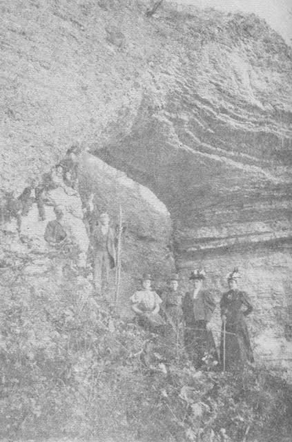
A "gay nineties" Easter Sunday party at the Arch on James River. From an old photograph contributed by Mrs. Fred Steele of Hurley who was then Miss Mollie Barnett, extreme right with cane.
Rooted in the soil of the ground floor between the Arch and the limestone cliff is the tallest, straightest tree. As one stands pondering the struggle that tree must have had to hold its own against great odds, one admires its tall, straight and very slender trunk stretching up and up to gain its place in the sun. Older residents remember the tree in its early days. "It was just a little sapling when I came here," said one man. "Now look at it." The view from the top of the Arch is breathtaking at any time of year and is especially so when Autumn wraps the hills in a paisley shawl. Then, the river flows gently along in no special hurry to get anywhere. Along its winding way it holds in friendly embrace rich valley lands and timbered slopes that end at the water's edge. Beyond and away are the home dots on the horizon, the cattle barns and hay mows, the sheep sheds and chicken houses. The whole world seems to unfold in colorful panorama. One can almost imagine the approaching step to be that of a moccasined foot, traveling the Indian
[2]
trail that led across the top of the Arch on to Delaware town in a northerly direction, and southward some distance through Sugar Camp Hollow. In the early days, many Indian pieces, including a complete grinding mill, were found near the Arch. With almost every plowing of the bottom lands, more than a hundred years later, arrow heads turn up with the rich soil.
Among the first settlers in the river country around the Arch was one John Inmon who migrated from Tennessee just prior to the Civil War. Hardly had he finished his first home when it was burned to the ground by a band of pillaging outlaws. He went to work at once, building another home of logs.
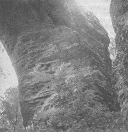
One span of the rock bridge and the limestone cliff at the back. Trees to the left are above the James, and give an idea of the height of the Arch.
At first the Inmon farm consisted of 160 acres, then later the claim of a man who failed to prove up his homestead was purchased and added to the original acreage. Inmon relatives pass along the story of John Inmon's early knowledge that there was such a place as the Arch. He had gone looking for a calf that had strayed away, and the first thing he knew he was riding his horse across the top of the Arch..
During the years John Inmon farmed his land almost within the shadow of the Arch, he picked rock in his spare time and built fences to enclose his fertile fields. When he was on his death bed, he requested that his final resting place be on the hillside near his home. The request was carried out. The tomb of John Inmon, and stretches of the rock fence he built with patience and hard work, can be seen on the farm which still bears the Inmon name.
The face of the earth around the Arch has changed in a century's time. So, too, has the Arch changed. It has been called by various names, for instance it is still sometimes called the Inmon Arch. Actually, though, it has never been Inmon property. James River was designated as a boundary line, but in using it as one, it cut a three-cornered tract off of forty acres belonging to Aaron Flood, a neighbor of John Inmon. And on the three-cornered tract is the Arch, now owned by a granddaughter of Aaron Flood, Mrs. Floyd Wilson, whose home is in California.
Travel memory lane to the Arch with me, if you will, on an Easter Sunday in the "Gay Nineties." Someone always got up an Easter party, complete with traveling photographer, to spend the day at the Arch, roam around over the hills, have an egg roast at noon and eat the great quantities of food stowed away in the backs of the buggies making up the procession. And always there were mementoes of the happy occasion, enlarged photographs mounted on stiff cardboard.
Perhaps young folks of that gay nineties period "claimed" the Arch as none have done since. It was just the right distance for horse and buggy travel. It was exciting enough to keep the most adventurous person interested, for there were Indian arrows to hunt, boating on the James, wild flowers to pick, and it was nice just to sit on top of the Arch and gaze off in the distance. If there had been a local tourists bureau in that long-ago day, I'm sure it would have publicized the Arch as THE perfect picnic spot.
Dense growth of brush and trees makes it almost impossible to photograph the Arch now, except from the air. In fact, it can hardly be seen from the River by fishermen floating to the Blue Hole where the big catfish stay. Arch "buffs" have asked permission of the owner to clear away the growth, making picture-taking a reality. To date such offers have been declined.
Have there been efforts made to "get the Arch on the map"? Yes, indeed! But to no avail. So there it is, hidden away in a sylvan retreat, the Arch on James River.
[3]
This volume: Next Article | Table of Contents | Other Issues
Other Volumes | Keyword Search | White River Valley Quarterly Home | Local History Home
Copyright © White River Valley Historical Quarterly
