 |
Vol. IV, No. 1, Summer 1990 |
Preservation Corner
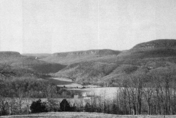
Boxley Valley
Buffalo National River--A National Park Service Historic District in Private Hands
Story by Jim Liles
Photos by Susie Rogers, historian, Buffalo National River
When Buffalo National River came into the National Park System March 1,1972, it included 24 bottomland farms, with more than 50 inhabitants--most descended from the early 19th Century pioneers who settled the seven mile stretch of river once known as "Big Buffalo Valley." It is now "Boxley Valley."
Think of Boxley Valley as a kind of Cades Cove, only in north Arkansas rather than east Tennessee. Cades Cove and Boxley Valley are similar in size, heritage, and historical aspect.
Cades Cove is a famous "museum landscape" of the culture of the Southern Highlands, located in Great Smoky Mountains National Park. Cades Cove was a living community until its population was displaced by the creation of the National Park in 1930. As in other units of the national park system created at that time, little or no recognition was accorded either the cultural landscapes that might have pre-existed the parks or their human creators. When Great Smoky Mountains National Park opened, the people of Cades Cove were gone.
Today the little valley in the Smokies is a "ghost settlement"--and, however poignantly attractive
to park visitors (as evidenced by the numbers hiking, motoring and bicycling the cove's trails and
roads)--its remnant landscape conveys but a suggestion of the cultural vitality a visitor to the
Cove would have experienced between 60 and 160 years ago.
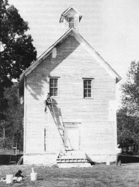
Boxley Community Building, on church property, is privately owned and maintained. The structure dates from the late 19th century.
[15]
Buffalo National River was to be different. Congress's enabling legislation explicitly provided for the retention of Boxley Valley's living community and its lifeways. That objective was an integral part of the park's design. To secure passage of the bill, former NPS Director George B. Hartzog articulated the concept of setting aside a "private use zone," including Boxley Valley, where land could be left in private ownership. The Service would acquire only scenic easements for preservation of the rural community and its pastoral landscape. This concept, in addition to being clearly enunciated in the park's legislative history, was iterated in its master plan: "A private use zone containing 9407 acres, including some farmlands, should continue in private ownership subject to scenic controls and necessary rights-of-way for roads and trails." In an earlier day of NPS history, such an idea would have been labeled heresy: a unit of the national park system (and a natural area, at that) authorized to embrace ecologically sustainable human activities, on perpetual private inholdings!
But the radical new idea was not implemented. Fully 75% of the lands within the designated private use zone were acquired in fee simple by park land procurers. Many residents left. The reasons for failure to leave Boxley Valley in private ownership are various. It is a sad story, one which produced disappointment, resentment, and antagonism. The opportunity to keep Ozarks folkways alive in a seven mile stretch of Buffalo National River, where a rural community had flourished for 150 years, seemed lost.
By 1982, many of the once-proud homes and farms purchased by the Service were vacant, neglected, even removed. The remaining population of the valley, some forty individuals, were unsettled and even embittered by a decade of land acquisition carried on by the Park Service. The valley was a crazy quilt of ownership situations. They included vacant farms and structures owned by NPS; occupied farms owned by NPS and leased back to residents for up to 25 years under life estates and rights of "use and occupancy;" farms for which NPS had acquired only "scenic easements;" and some in which the park had acquired no interest at all. To locals, however, the trend appeared to have been to acquire all the valley and get rid of the people.
The trend was to be changed. In 1982 Park Superintendent Alec Gould decided 1) to preserve and perpetuate the valley's impressive cultural landscape, and 2) to improve relations between the Park and valley residents. Cultural resources specialists from the NPS Denver Service Center and the Regional Director's staff in Sante Fe drafted a new master plan for Boxley Valley. Residents were invited to participate in this planning effort, and their comments influenced the result. The document, (Land Use Plan and Cultural Landscape Report, Boxley Valley) (1985) led to the understanding that Boxley Valley, as a distinctive cultural landscape, was eligible for inclusion in the National Register of Historic Places. Boxley Valley contains over 200 structures of historical significance. Houses and barns, a grist mill, and a community building are fine examples of regional vernacular architecture. Many date from the last century. In 1987 Boxley Valley entered the National Register as "Big Buffalo Valley Historic District".
The two planning years of resources assessment, meetings, and informal talks with the Boxley residents confirmed park managers' belief that Boxley Valley bottomland farms and homes already acquired by the Service should indeed be returned to private ownership. Now approved in the Boxley Land Use Plan, the opportunity existed to offer the former landowners--those who stayed on as life or term tenants--the opportunity to reacquire their former lands. Forested slopes, the river itself, farm management easements, water quality protection, historic structures preservation, and appropriate visitor access would be retained by the National Park Service. (The valley contains historic features valuable for interpretation, and a beautiful natural area, "Lost Valley," accessed by a popular hiking trail.)
The intent of the plan is to preserve the opportunity for the continuation of a population with
distinctive ties to the land, as manifested in the valley's cultural landscape. The historic district is
home to 14 families and 4 individuals, and the population is expected to increase as the park
service returns 4 vacant historic farms to private ownership in the near future.
Walnut Grove church and community building in center of Boxley Valley.
[16]
Since the plan's approval, negotiations have proceeded with a dozen families interested in buying back their old farms and homes. The first such conveyance was successfully completed in June, 1987, and two more "land exchanges" were executed in January, 1990. (An "exchange" occurs when the right of use and occupancy--a legal interest--is quitclaimed, in exchange for a fee title granted after a cash payment to the United States, equalizing values set by an appraisal.) Four more such exchanges are awaiting appraisals, as are four "sellbacks" of vacant, park-owned farms, which are expected to be sold on the open market by 1991, subject to protective covenants (deed restrictions).
Not all the valley is to be returned to private ownership. Along a one mile stretch at the valley's north end there are no occupied farms. Open fields lie below uninhabitable historic structures with interpretive values, including two log houses pre-dating the Civil War. Near the valley's center stands the two-story grist mill built in 1870 and the log house and barn of the first miller. The lands associated with these significant resources will be kept in park service ownership, made accessible to visitors, and maintained by "historic leasing," pursuant to the National Historic Preservation Act, as amended in 1980. Three such leases comprising 100 acres were awarded February, 1988, and three more comprising 96 acres were awarded in February, 1990. This mechanism for land management is resulting in visible improvements in historic structure and landscape maintenance, because the terms of historic leases provide positive incentives for lessees.
An equally gratifying effort is being put forth by the Boxley community to preserve and improve
lands and historic structures in private ownership. Owners whose lands carry new historic
preservation and farm conservation covenants work in partnership with park staff, not only to
rehabilitate historic structures, but to construct new barns, fences, and other farm structures. In
one case, a fine new family home was built. (The Boxley Plan allows for construction of a limited
number of additional houses, on selected sites and in accordance with several restrictions in the
easement, encouraging designs that will be harmonious with traditional landscape features.)
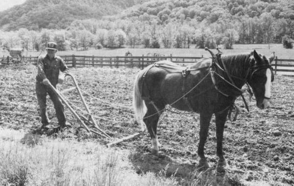
Plowing a garden the "old way," on a privately owned farm in Boxley Valley.
[17]
Land ownership promotes pride and effort in land caretaking. After a decade and a half of declines both in population and the level of care given structures and farms, things are definitely looking up in this 5% of Buffalo National River called Boxley Valley. It is a striking community of farms and homes, occupied by hard-working, intelligent and outward-thinking individuals whose land ethic derives from their ancestry. The landscape resulting from that successive stewardship is a pleasing visual mosaic: forested hop lows and slopes ascending from a pastoral valley floor comprised of wooded river corridor, small farms, and historic homes and barns.
Boxley Valley is flanked on either end by legislated wilderness. In a matter of minutes, from a valley vibrant with human activity a visitor may canoe, walk, or ride horseback into relative solitude. The national river is made all the more interesting by virtue of this diversity and contrast. Thanks to the on-going effort to keep alive the story of the river's people and their relationship to the land-an effort permitted by the national river's non-traditional legislative his-tory--some of the river's pioneer tradition lives on.
Jim Liles is Buffalo National River's Assistant Superintendent. He has been responsible for
guiding implementation of the Boxley Plan, at the park level, over the past five years. On
November 10, 1989, at an awards ceremony in Washington, D.C., Jim and Ric Alesch, park
planner with the Denver Service Center, co-accepted on behalf of the National Park Service, a
Presidential Design Excellence Award for the Boxley Valley Land Use Plan and Cultural
Landscape Report. The first such report for any area in the national park system, it described an
innovative resource management concept for preserving the special, living cultural landscape of
the Boxley Valley while protecting critical natural resources at Buffalo National River.
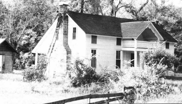
Repointing a stone chimney on the historic Casey-Clark house. One of two interior pens is log--possibly predating the Civil War.
[18]
Copyright -- OzarksWatch
Next Article | Table of Contents | Other Issues | Keyword Search
