 |
Vol. IX, No. 2, 1996 |
Preservation Feature
Dwellings of the Flood Buyout
A Warren County, Missouri, Case Study
by Robert Flanders
I pointed the old gray Chrysler down Ballman Lane, a mere dirt track through wide flat fields of the Missouri River floodplain. Last year's grass brushed against the oil pan. One fifty foot stretch almost got me. A nearby spring had turned river silt to deeply rutted mud. "No-bottom mud," my father would have called it. The front drive wheels slithered sideways, wallowing, out of control. Old gray car stuck in old gray mud, I thought. Living in the Ozarks nearly thirty years, I can't even remember being mud-stuck. I kept trying, now a little more gas, now a little less. Rock, stay with it.
I like gray--"lively" gray. Its a favorite color. The flat gray of this mud, these fields, the trees, the sky, the seething river itself, was not pretty. It was unnerving. I missed the warm brown of Ozarks winter. Get a grip, Robert. You're just not used to it yet. Its not your gray.
The Ballman place was at the end of the track, half-hidden in the head-high stalks of last year's weeds. In what was once the back yard reared the high wall of the Lake Creek levee. Broken glass under the tires came from shattered windows, probably vandalized in full daylight. It's isolated, out-of-the-way. Once a busy road passed the front door, the road from the Washington, Missouri ferry landing to Dutzow before the present bridge was built. Now the door opens out on plowed fields. The vacant windows are like sockets without eyes. Unnerving. Later, Bonnie Ballman would tell me, "I loved that place. It was pretty. I grew up there. We married there, raised our family there. It was home."
I'm on my way to assess six houses flooded in the great Missouri river overflows of 1993 and 1995. The Ballman house is one of them. Though difficult perhaps to comprehend at the outset of my journey, these devastated houses would yield useful information to our growing understanding of the buildings and building practices of the past-- these houses that I had yet to find, houses I would study, photograph, and in a peculiar way develop affection for. I had the opportunity and responsibility to assist in preserving additional knowledge of the places we call home.
1
In January, 1996, a call came from the Booneslick Regional Planning Commission in Warrenton, Missouri, on behalf of Warren County. Would I be interested in bidding on an historical preservation job at Marthasville?
I got the job. It was to investigate and report on houses slated for demolition that had been identified from snapshots as having "potential historical significance.'' These words have an official import. Warren County, purchaser of the houses, had responsibility to investigate.
The houses will be razed because they are in the floodplain of the Missouri River and have been
repeatedly inundated, most recently in the floods of 1993 and 1995. Those calamitous events
precipitated "the flood buyout program," as it is commonly called. Local governments---county or city--offer owners the opportunity to sell at appraised
prices and get out of the flood zone. The money is mostly federal money, dispensed by the Federal
Emergency Management Agency (FEMA).
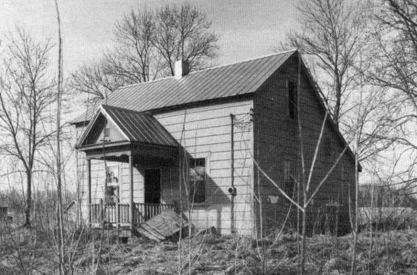
Ballman House. Levee in right background. Open cellar door, right of porch.
[19]
I drove the two hundred plus miles northeast from Springfield to Washington, Missouri, then across the old (and, it seemed to me, rickety) bridge over the rolling Missouri River, out onto the broad flat floodplain where the subject houses are.
What has that place to do with the Ozarks?
This is a story of historical preservation, in Missouri, and in the United States, which knows no regional boundaries. The flood buyout is occurring everywhere in the Mississippi Valley, including the Ozarks. And, strictly speaking, the Missouri River and its valley cut through the northern Ozarks border. Going north out of the valley, climbing through the bluffs, you re-enter as Ozarks-y a landform as you could imagine. It's still "the driftless area," land not touched by glaciers during the ice age. Only north of Warrenton, the county seat, do you enter the Till Plains, the glaciated landform typical of north Missouri. Furthermore, the floodplain is a Missouri German place like so much of the North and East Ozarks Borders. (The great Charles Van Ravensway called Warren County "the most German county in Missouri.") The house names, after the latest owners, are Ballman, Gadde, Hellebusch, Meyers, Schwoeppe. Only one is "Smith." Two of the owners, though life residents of Missouri as were their parents, speak with distinct accents. All were delightful people, open, hospitable, ready to help me, show me family treasures, and answer my questions when they learned what I was up to.
2
And what was I up to? Paraphrasing the language of the 1966 National Historic Preservation Act, I was part of the process intended "to protect the history and heritage of the United States for the benefit and enjoyment of future generations." This includes "mitigating the adverse impact" of the government itself. Tearing down a house is undeniably an adverse impact; and the whole point of the flood buyout programs is to get such houses out of the floodplain. The money comes from the feds, making this a federal action. What is to be done to "mitigate the impact?"
Moving threatened houses is one possibility. In fact, one of the Warren county houses may be repurchased by its former owner, moved to higher ground, and resold or rented, thus both saving the house and potentially profiting the owner. But this solution is always expensive and therefore risky. It is, unfortunately, seldom used. Other means must be found to "mitigate the impact."
Two questions arise here: First, are these six houses really "historic?" And second, if so, what can be preserved of them that will help "protect the history and heritage of the United States?" My Warren County work represents a case study of how these questions are approached and answered.
The first question, "Are the houses historic?" is a knotty one. When I worked along Walnut Street
in Springfield in 1981 doing an historical study of the neighborhood (in technical terms a "cultural
resource survey") anxious owners would ask, "Is my house historic? You know, its almost a
hundred years old, my grandparents built it, four generations of our family have lived here." Etc.

Schwoeppe House
But when do such personal matters bear on the history of the United States? When do private family histories merge with histories of town, county, state and nation? Can judicious general criteria be established to separate the truly historical sheep, so to speak, from the non-historical goats? An answer is to use the criteria established in law to determine the eligibility of any building, structure, object, district or site for listing in the National Register of Historic Places. The National Register has four criteria:1) Is the property significant to the history of the United States (including state, county, city or locale)? All national battlefields, as an example, are listed in the National Register under this criterion.
2) Is the property significant for its association with a person or persons important to the history of the United States? George Washington slept here, a Lincoln-Douglas debate occurred here, etc. But, important as places associated with the already famous are, thousands of persons and families significant to state and local history previously little known have been rescued from anonymity by nominating their associative properties to the National Register.
[20]
3) Is the property significant to the history of American architecture and building ? In the early years after the National Register's establishment in 1966, most of the nation's great architectural monuments, those not already designated National Landmarks, were listed. After them, what? In fact, by now thousands of the places in which ordinary Americans have lived, moved, and had their being have been listed. At present most new Register listings are made under the architecture and building criterion. Great county courthouses; the folk housing of common people (the Parker-Hickman single pen log house at Erbe, Newton County, Arkansas, for example); the streets where our forebears lived, worked, bought their groceries, have been listed. Springfield has its Walnut Street, Commercial Street, and Mid-town National Historic Districts. In Warren County, if any of the six subject houses are judged officially historic, it will probably be under the architecture and building criterion. One is timber frame construction, a medieval building practice. One is a pristine cross-plan house. One is a very German farmhouse, the many building episodes of which I was fortunate enough to uncover. And so on.
4) Is the property significant for its potential to yield knowledge at a future time, i.e. its "research potential?'' This criterion usually applies to archaeological sites which have not yet been completely excavated-as most have not.
The two questions: Is it historic, and if so what can be saved, were both included in the Warren County contract Scope of Work. They were denominated "Phase 1" and "Phase 2." Phase 1 called for the history of the houses, together with descriptions of their architecture, building method, materials, relation to known patterns of vernacular houses, etc. The intent is to learn if they fit any of the NRHP criterion. To continue the sheep and goats analogy, I was not given the authority to make the separation, only to provide information to those who would.
Authority and responsibility to judge legal historicity resides with the State Historic Preservation Officer in each state. In Missouri that person is the Director of the Department of Natural Resources, an officer appointed by the governor and approved by the Senate. In other states the SHPO may be chosen differently and carry different portfolios. In Illinois, for example, the SHPO is the State Historian, an office which does not exist in Missouri. Missourians will not be surprised to learn that our SHPO's staff is small relative to its responsibilities and work load. But it is a capable and dedicated group. Director of the Historic Preservation Program is Claire Blackwell, an architectural historian who carries the portfolio of Deputy State Historic Preservation Officer. Laura Sparks, another architectural historian, is a staff person with preservation oversight of the flood buyout program. A specific job: perform a DOE (Determination Of Eligibility) on each buyout property. Is a property eligible for National Register listing? That is, if nominated and taken into the arduous and exacting process of nomination review, would it meet the basic criteria for consideration? This Determination Of Eligibility is a legal determination: if determined eligible, a property falls under similar protection of law as if it were actually listed in the NRHP.
My Phase 1 report from Warren County was designed to provide Laura Sparks and associates sufficient information to do a DOE. If any of the houses were determined eligible, they would then undergo the Phase 2 process, "recordation."
3
The Missouri River floodplain is a different world. Like the Ozarks, it is a world made by water; but there the similarity would seem to end. Its width varies from several miles to little or nothing. Evidence of flood is everywhere. Meandering creeks with steep mud banks have been scoured by repeated torrents. Great trees are occasionally seen toppled into them. The land, unless plowed, shows riffle marks, like a beach. Vast drifts of whitish sand from the floods of '93 and '95 dot the fields. One I saw, still being removed, was hundreds of feet long and twice the height of the huge trucks hauling it away. That drift is actually one of the infamous Missouri River sandbars. It's just not in the river--at least not at the moment. Few houses are left in the floodplain. Many are empty. In late winter, before spring greening, the broad, flat, gray landscape, treeless except along stream courses, reminded me oddly of a sea, with scattered buildings adrift upon it. Some houses, especially those built since World War II, sit on high man-made islands, designed to be above the floods. Whether they escaped the '93 water depended on how high their islands were. I was in one house, now abandoned, sited on a natural knoll, where water marks were at head height. How unsettling to see three inches of mud on every stairtread nearly to the second floor!
The only directions given me at first to find the six object houses were mailing addresses, post office Marthasville. Only one was even near the historic little village. I found them through local inquiry. "Where is the Schwoeppe place? ...Oh, I suppose there are a lot of Schwoeppes...The Meyers place is off Boeuf Island road? That isn't graveled all the way, is it? Yes, I'll need to be careful...The appraisers' sketch map shows the Ballman place beyond Dutzow, but that can't be right. Beyond Dutzow is the bluffs...The Hellebusch place is west of Peers? Where's Peers?" And so on. When I was in the County Recorder of Deeds Office in Warrenton, I said, "The river down there has changed its course so many times over the years. How can I tell if the land surveys..." The Recorder cut me off. "I don't talk about the river changing its course," she said in a tone combining irritation and resignation, as if to say, "Oh, don't start that again!"
[21]

Meyer House
I finally found all the houses (the first three I visited were the wrong ones). They are all different. None are "distinguished" in any ordinary meaning of the term. Only one, the Ballman house, was built before 1900 (probably 1891). Two are distinctly Missouri German farmhouses. Two are somewhat in the bungalow style. Only two are on paved roads. They all have one thing in common: the floodplain.Reaching the Meyers house, the one off Boeuf Island Road, was an adventure. It can be seen for miles, an island in the vast plowed fields, a boxy white story and a half bungalow in a tiny grove of ancient sycamores. Getting there required driving a half mile or so over an ungraveled dirt road, dirt exactly the same as that of the surrounding fields. It's river silt, a crystalline material fine as powder. The first time I drove onto it, I retreated carefully after the first hundred feet or so. Needs a spring grading, I thought, and maybe a new dressing of crushed rock (the kind of rock put on the roads here was new to me, crushed stone the size of pullet eggs--to keep it from sinking so fast, I supposed). I'll wait until later, I decided.
After I had visited all the other houses, waiting as long as possible, I had to try again to go to the Meyers place. When I got to the scary part of the road, what should appear but a road grader coming toward me. What luck! I waited, watching it mound up the dirt crown good and high. As the grader chugged away behind me, I proceeded--and immediately sank into a substance that felt somewhere between powder snow and sand. It did not pack down under the wheels. I slipped sideways, as I had done in the Ballman Lane mud; but here going sideways very far would topple me into a deep ditch. I crept. Without front wheel drive I wouldn't have made it. As Mark Twain said of the Missouri River, "Its too thick to drink, but too thin to plow!"
The Meyers house has a gaping wound where a flood-borne limb pierced a window and wrecked the interior support wall, causing both first and second floors on one side to collapse into the basement. On the other side, the living room floor has drifts of mud a foot or more thick. The house is too dangerous to en-ten Though the winter had been dry, the basement was still full of water, and mud ringed the house outside. The view from the front porch is miles of flat plowed fields. Only five paces beyond the porch steps the big furrows begin, unmoving waves in a sea of silt borne in on floods that first came when the glaciers melted. And, I reflected, they still come.
4
I love this work. Never mind my moody start. Every house, every informant, revealed something interesting, surprising, unique. Two houses were still occupied, one by renters I never found--though once I waited for them until dark. One house still had canned green beans and pickles sitting on the well curb. Some were wrecks; others were as though the occupants had just stepped out.
The Hellebusch and Schwoeppe houses both have paired front doors opening off neat front porches. But, I suspected, those doors were seldom used. Each Hellebusch front door opened into a bedroom, one with the only bathroom (not original). The parlor was at the rear, next to the kitchen. Said Barbara Schwoeppe of her paired front doors, speaking in a rich Missouri German accent, "That was a bunch of nonsense, those doors." She laughed. "They didn't go nowhere anyway, only out to my garden!"
[22]
The Schwoeppe house had been her home since she married George Schwoeppe in 1939. She described its many building episodes. First was a one story, two room building with a porch. That part is now the kitchen and dining room. Then two more rooms were added across one end, making a "T". Later, two upstairs rooms were built above the cross block, with a staircase up from the dining room of the original structure. ("We didn't eat in there much, we mostly ate in the kitchen.") Then the porch was enclosed, the house raised, and a basement added. Electricity and running water were not introduced until 1951. Getting the story of the many additions helped me understand why Mrs. Schwoeppe called the kitchen door "the front door" and the two story block "the back of the house."
Flood water inundated the Schwoeppe house nine times during Barbara Schwoeppe's tenure, including eight of her first thirteen years. After a big flood in the summer of 1951, the decision was made to raise the house five feet by putting a basement under it. A St. Louis contractor took the job for $500, and brought truckloads of railroad ties for cribbing. Then September rains and a rise in the river threatened to float them off. "Boy," said Mrs. Schwoeppe, "did we ever put ties up on all the roofs around!" The house raising was accomplished, and floods in succeeding years were kept at bay--until 1993.
The flood of '93 was especially filthy. The high water was full of mud, with little current, and it remained for weeks. Each flood is remembered for some distinctive signature. "Now that '86 flood was quick and clean," I was told. "It was after they opened Bagnell Dam. Water came up fast, rushed through, then went down. Not so much mud." Other floods--'73, '51, were mentioned. But nothing, nothing, like the flood of '93. Then the flood of '95, "not as bad, but bad," administered the coup de grace for many floodplain dwellers. It came just after the post '93 cleanup and fixup. Ruination of the attempted recovery appeared every-where--newly painted exteriors, redecorated interiors, new carpeting, wrecked again in '95. "The '93 water came up to the height of the kitchen counters," said Dave Gadde. "The '95 water came to here," pointing to a place above the wide old-fashioned baseboard.
"I really miss the old place down there," said Bonnie Ballman as we sat in her new home in the hills north of Marthasville. "My husband Fritz is a builder, and he fixed it up real nice. The yard looks terrible now, but it was always mowed and neat." She had lived in the house since her parents bought it in 1954. When she and Fritz married in the 1960's they bought it. "It was special to my folks because it was the first house they ever owned." I found it difficult to imagine the Ballman house as Bonnie described it.
Going into those empty houses, some not even hosed out after '95, gave me a strange feeling. Lonely, isolated places; open doors banging in the wind; broken windows with curtain shreds blowing through them; new carpeting caked with platelets of dried mud shrunken and curled up at the edges like reptile scales. The silt is so fine that its dried surface is very smooth. It looks almost polished. Part of the strangeness of being alone in those lonely houses is realizing what they had been to those whose homes and farms they once were. "That's the old Morehouse place; Arthur Morehouse lived there a long time." "That was part of the old Brehe farm. Brehes still farm next door. .... It was split off from the old Reverend Poepsel lands, long ago." The Hellebusch and Schwoeppe houses, though built in this century, are on lands owned by the families since long before. But, I reflected, my feelings, as theirs, about home have little to do with the question, "Are these houses historic?"
Do our feelings count for anything? I remembered the fervent queries of the Walnut Street people in Springfield. Does home finally have to do with history? Everything about the past that is known, remembered, cherished, at least partly understood, is someone's history. Put into some context--a place, a flood event, a fire, an earthquake, an ethnic group, something else--they are certainly part of our national heritage.
Thirty years ago old places were usually just to tear down, remove, clean up. We have made
progress since then. Jim Denny, staff member at DNR and one of Missouri's experts on our built
heritage, once said to me, "Plans and photographs are often all that can be preserved. Its better
than nothing. Actually, its not bad, considering that the structures themselves are so often
inevitably lost." As for the six Warren County houses in my study, whatever happens, their history
has now become, by some mysterious transference, a part of my own. History is like that.
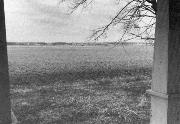
View from front porch of Meyers house across floodplain. Bluff line in distance.
[23]Copyright -- OzarksWatch
Next Article | Table of Contents | Other Issues | Keyword Search
